
Albany River in Ontario
Trip Overview
ALBANY RIVER: Osnaburgh Lake to Fort Hope
This trip report was supposed to be about the Pipestone River. Unfortunately large amounts of rain in late June and early July forced us to change our plans at the last minute. The Albany River was our alternate river plan.
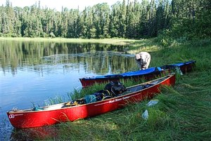
The Albany is the largest river in Ontario. There are many sections that can be paddled and trips can range from several days to several weeks. To make this trip happen we had sought the help of a local outfitter to provided us with maps and shuttles (bus in, flight out) we provided all the other items required for the trip. Our road journey started in Madison, Wisconsin and the destination was Pickle Lake, Ontario. Our crew comprised four guys and one woman, all experienced paddlers.
The road from Ignace to Pickle Lake was long and twisting with some very rough sections. After having destroyed a tire on the way, we finally arrived in Pickle Lake in the middle of the afternoon. We met our outfitter at the airport where his business was located. A shuttle to the Albany for that day couldn't be organized so we were forced to wait until the next day to head out. The outfitter had a private camp site near a creek north of town where we camped for the night. The black flies and mosquitoes were awful at the site, we realized that this was going to be a bug-jacket trip.
Day 1 7/9/07 (27 km)
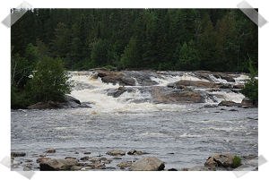
We returned in the morning at the airport and loaded all our gear on a small bus. The fellow that give us ride was an ice truck driver in the winter. We enjoyed listening to his stories on our way to Osnaburgh Lake. The put-in was located off of Highway 599, it was a partly cloudy day with the temperature in the 60's. Only a good wind kept the black flies from eating us alive. Osnaburgh Lake is a big lake. To cross it, we hugged the southern shore and hid behind a rather long island to avoid a strong N-W wind. We eventually entered the river at the East end of the lake, where we briefly stopped for lunch at a small rocky island in midst of large boulders located in the middle of the river. The Albany was already a big river at this location and the water level was definitely up. A bit further down river we encountered our first rapid; an easy CI. After the rapid, the river split into two branches with a large island in the middle. The map indicated a passage in the middle of the island. We explored the passage but it was obstructed by a beaver dam. We proceeded around the island a bit further south where we encountered a second rapids. We judged this rapids to be a CII, not too difficult as long as a good route was chosen. A bit further down we paddled another CI that was followed by a CII. The second rapids required some maneuvering through a rock garden. The river opened up into Lake Atikokiwam and resumed in the north East corner near a nice sandy beach that was marked on our map as a camp site.
We paddled another five kilometers and decided to look for a campsite. The map provided by the outfitter indicated several campsites but most of them were nonexistent. Eventually we found a place on a rocky ridge around KM 25 on river left. We scrambled to put up our tents but it turned out OK. As expected by now there were lots of insects. We were wearing our bug jackets at all the times. Before we left for the trip I had mentioned to the crew that I will bring my bug tent, it was initially greeted with puzzled looks, but a few days into the trip, they were made into believers. After a few cacao plus (hot cacao with whiskey), we had our first meal in the wilderness. We finished the day with a round of euchre (card game) in our bug tent and called it a day.
 Day 2 7/10/07 (10km)
The day started partly cloudy, and the weather turned into off and on rain. At times the sun would come out and it really warmed up but it never lasted very long before it rained again. This forced us to keep our rain jackets handy at all times. After a short paddle, we came to some major rapids at KM 30. The portage trail was on far river left. The trail was a bit hard to find because the river is very wide at that location. There was also a good camp site at the beginning of the trail. The portage was long with wet spots and poor footing in places; it ended with a good downhill gradient.
After the portage we paddled for another few kilometers and encountered a few swifts and a CII. According to our map we knew we were getting closer to Kagami Falls, once the river splits around a relatively large island. From there on, we proceeded carefully forward hopping from eddy to eddy. Greg in his solo canoe, was the leader and we all followed. Eventually the portage trail was visible on river right. Beside a couple of ridges the trail was good and ended at a great camp site where we opted to stay for the night. Kagami falls was very scenic. We tried our luck at fishing but only Paul was able to land a walleye. Again, the mosquitoes were very active in the area; definitely bug jacket and bug barn country.
Day 3 7/11/07 (40km)
Morning came fast, we ate a quick breakfast and launched. The next portage was only a Km ahead and was on river left. It was not very long. This was followed by another set of rapids of grade C2+ that we ran river right after carefully scouting it. The section of the river that fallowed was not particular interesting; the shore was covered with marsh grass and brush. We push on against a head wind a times and an occasional rain shower with little to no current. As we approach Km 77 the current picked up a bit and we encountered a few swifts. The last rapids for the day was marked as swift on our map, but turned out to be a CI-II. We put up camp on a river bend around Km 78 on a reasonably flat, rocky and grassy area. A nice cold spring was running near camp and provided us with cold drinking water. I tried my luck at fishing and my first three casts produced three nice walleyes that were later featured as dessert at supper. We were all tired from the long day paddle we enjoyed hot cacao with whiskey. We played cards before crashing out for the day.
Day 4 7/12/07 (0 km)
During the night we could hear the pitter-patter of the rain on our tent. I believe it was Greg's turn to make breakfast that morning, "red river" was on the menu. The rain had stopped it was the usual; partly cloudy with an occasional shower. Since we had covered so many miles yesterday and fishing seams to be good here we decided to take a layover day. After breakfast we started fishing and within a few casts I caught five northerns. We do not like hammer heads (northerns), they fillet poorly, are slimy and full of bones so I did not keep them. I moved upstream a bit and soon I was caching walleyes. The insects were bad, both mosquitoes and black flies. At one point I accidentally let part of my back exposed, it immediately became a bulls-eye for black flies. Something I regretted a few days later as I looked at my mangled torso. Heather relaxed and journaled, while Greg took a nap and also did some fishing, Paul, Tom and myself were working on catching fish for lunch. We only kept fish in the 18 to 22 inches range and by noon we had 12 nice walleyes. We filleted them out and eat them for lunch. Needless to say they were delicious. In the afternoon we caught just as many and cooked them up for supper. It was a great fishing day and we all had our fill of fish for a few days. We also relaxed, took a bath, played cards, and were fully recharged for the next day.
 Day 5 7/13/07 (27 km)
In the morning we said goodbye to our camp site and paddled on. Within a few kms we hit a few CIs, followed by a significant drop of grade CIII. The portage for this rapids was on river right but we opted to lift over a rocky ledge and ran the bottom section of the rapids (CII). There was also a nice camp site at that location. Next set of rapids was about one km down river it was a multi ledge type rapid (CII-III) extending a long way across the river. I wish I would have a rapids like this in my back yard. A perfect spot to practice WW! There were so many routes one could take ranging from CI to CIV. There was a good portage trail river left but it had a steep take-out with a good trail. We scouted the rapids as good as we could from the portage trail and ran it river left with no problems. The outfitter map indicated several nice rapids to follow but at the water level we had they were barely rifles. The next 10 km of river travel was relatively uninteresting. We found a good camp site at river left at around KM 105. It had been used for hunting or fishing judging from the trash that was left over. It can easily be missed so one needs to keep its eyes open. It was a fairly roomy site, we put up camp in the midst of pine trees. We finished the day in the bug tent, discussing and trying to find solutions to the world's problems.
Day 6 7/14/07 (23Km)
Got up at 6:30 and were back on the river at 9:00. We first encountered a small rapids (RI+) at about 1 km from camp. We latter passed the portage trail heading into Snowflake Lake. A few Km down river the river split into multiple channels. We had to make a quick decision and took the far left channel, it was of grade CI-II. As it turned out it was the right choice, as we came around the bend we could see that the other channels were very shallow and would most likely have involved some walking.
After lunch we encountered an easy CII a few KM downstream and eventually we came to Upper Eskakwa Falls. The portage was on river right, about 300 m long, it had a tree lying across, but otherwise it was in great condition. The fall was very scenic and it also had a great camp site at the end of the trail where we stayed. It was early enough in the day, so we had time to explore, take pictures and try our luck at fishing.
Day 7 7/15/07 (18Km)
We left the great camp site and paddled to Lower Eskakwa Fall portage. The portage for this fall was on river left. Like most trails thus far, it was in great condition. It also featured a small camp site on the end of the trail. Lower Eskakwa Falls was very impressive, the bottom of the fall turned into a major whirlpool that would do you in for sure if you would accidentally go down this drop. Next, we came to Snake Falls. The portage was also on river left. The trail was in good condition a small camp site was also visible at the end of the portage trail. We had lunch and fished with some success below the fall. After Snake Fall the river turned into a long and monotonous paddle. We found a camp site on river right across the entrance on Howeels Lake. The site was difficult to locate because the shore line was so overgrown. The site had been used for hunting, it was mediocre at best and had some left over trash laying around. This was the only camping possibility before Lake Miminiska and we had no desire to push any further for today. We made the best of the site, used some wood cutting for chairs and played cards while having hot cacao with whiskey.
 Day 8 7/16/07 (21 Km)
Our day started as usual; breakfast, pack and on the water by 9:00. We entered Lake Miminiska and saw the first and only humans beside ourselves on the trip. They must have been fishermen from the fish camp located on the north end of the lake. Lake Maminiska was a large lake, we had a N N/W wind that pushed us along at a good clip.
At the constriction of the West and East part of the lake we stopped for lunch on an island used by the local fish camps. It was heavily used and was all setup to fry fish. One could probably camp here if need be, we proceeded to the portage trail located near the Y shape island. The portage begun on an old wooden dock that was falling apart. We opted for the long portage since we had high water and were unfamiliar with the portage on Maminiska Falls. We also had no desire to paddle back in case it would not work out. Apparently there is a CII before the fall and the fall has a short 100m portage. The portage we took was long (800m) but the trail was in relatively good shape. The end of portage was used for boat storage by the fish camps. We launched in the river and when we entered Petawanga Lake we passed an island where we briefly stopped to explore the camping possibilities. We felted the island did not have adequate space for four tents and decided to push on. We ended up camping past a point on the right, on a sandy beach in a cove. The tents were very close to the water line and could have been a problem for us had an eastern wind pick up. It was very nice swimming spot. I tried my luck at fishing, caught a few hammer heads which we did not keep. As usual we relaxed and played cards before calling it a day..
Day 9 7/17/07 (25 Km)
We woke up to a sunny and warm day. From the site we could see far on the horizon the passage we had to paddle too. It was a long way away, as this was a very big lake. Luckily for us we still had a NW wind that was helping us along and the water was relatively calm. We were making good time and arrived at the outlet of Petawanga Lake into Kawitos Lake. The passage started with an almost one km long CI-II rapids. We eddied out half way down and worked ourself over to an island to scout what was to come. The left channel was CII-III water, the right side, from as far as we see, was CII. We opted to run the right channel and had no problems. The rapids ended where the river branches came back together, with another small CI-II. We paddled for a few Kms in the river and just before entering Kawitos Lake we encountered another CI of no consequence. We followed the north shore for about one km or two and camped on another sandy beach. The site was mediocre and signs of being used before. No one was complaining after all beggars cannot be choosers, it was the best we could find. To satisfy our desire for fresh fish we returned to the last rapids we ran at the entrance of Kavitos Lake and tried our luck at fishing. We paddled up into the rapids and let ourselves drift with the current while jigging. We ended out with seven nice fish, not to bad for a hour of fishing.
Day 10 7/18/07 (15 Km)
It was another sunny day, even a bit hot. We proceeded to head East on Kawitos Lake. At the outlet of the lake and the entrance to the river we had to make a choice, the river was again splitting into two channels around an island. We opted to take the right channel since there was more water flowing in that direction. Soon after we encountered our last set of rapids of the trip. The first portion of the rapids was of CI+ but the last segment was of grade CII-III. There was also a portage trail on river left where we stopped to scout. With great disgust we were looking at the large amount of trash present at the take-out. We opted to portage the packs across and then made the decision weather or not to run it. Greg, being the most advanced paddler in the group, ran his solo canoe through it and came back and gave us a report. Tom and I opted not to run it, nor did Heather but Paul and Greg ran the last canoe trough it with no problem. Before entering Triangular Lake we paddled upstream a bit to see if the left channel would have been a better option as it turned out we made the right decision, this channel had a fall in it.
We stopped and had lunch on a big boulder in the middle of the river. Triangular Lake was another big body of water nothing particularly interesting about it. Clouds were starting to appear in the sky and it looked like a thunder storm was on its way. We were again on the lookout for a camp site and found one on the North shore about two Kms before entering the Eabamet River. The site was perched up on a rocky shore, it had room for at least five tents. We had just enough time to put our tents up when the weather turned. The sky turned a purplish color and all of sudden it let loose with a salvo of thunder and lightning followed by a massive down poor. Judging from the air traffic we knew we were getting closer to Fort Hope. We were also a day ahead of schedule and did not want to make this site a lay over site. So we decided to contact our outfitter via our emergency short wave radio. We knew the radio frequency of the company that was shuttling us back to Pickle Lake. It took a while but eventually we got a response from an overflying airplane and the pilot agreed to relay our message to our outfitter. It was our last night in camp, it is always hard when one realizes a trip will be over soon and within a few days we will be back in the rat race. The rain did not last too long and we sat on one of the big boulder that made up the shore and enjoyed the evening. Later we played one more game of cards and crashed out for the night.
 Day 11 7/19/07 (12 Km)
Before getting out of my tent I had to chase out several hundred mosquitoes that where trapped under my rain flap. There was no rain this morning but a strong easterly wind. One more time we broke camp and headed out on our journey. We followed the northern shore until we entered the Eabamet River. Progress in the river was slow since we were paddling against a current. At one particular location the river constricted and the current was very strong requiring a significant amount of effort to move on. Eabenet Lake greeted us with a strong head wind and waves. To regroup and formulate a plan to go forward we briefly stopped at a campsite on an island that was located just at the entrance of the river. This could have been a great camp site but it was deplorably trashed. The wind was strait from the East, our plan was to hug the west shore until we would have the wind head on for crossing over to Fort Hope. We could see Fort Hope on the horizon but we kept on going north until the distance to cross was at a minimum. Eventually we turned our canoes into the wind and waves and worked ourselves across Lake Eabamet.
Our plan worked, we all made it over safely and landed on the main dock of Fort Hope. We found a local fellow with a pick up truck that was willing to take our canoes and packs to the airfield located on the other side of town. After waiting a few hours our flight back to civilization landed on the gravel runway. The pilot first unloaded milk and other provision for the town before loading our gear. We nested the smallest canoe in the largest one which allowed the pilot to take the entire load and all of us in one flight. The pilot gave us a royal ride back following the river back to Pickle Lake. We took a lot of great pictures of the rapids we had run a few days ago. At times we were only flying 30 or 40 ft above the water. When we arrived in Pickle Lake our outfitter was waiting for us with fresh cold beer. What a way to end a trip.
General comments:
The Albany is definitely a big river. We ran it at high water level so one needs to keep in mind that the rapids ratings will most likely change at different levels. We did not see any other paddlers on our trip and it was certainly a good wilderness experience. All the nice camp sites are on the major falls, to find good sites at other places can be a challenge and one cannot be too picky. The fishing was excellent, especially bellow the rapids. Once we entered Lake Miminaska, and from there on, it is almost exclusively lake travel. We had favorable winds but one needs to keep in mind that this might not always be the case. The rapids we ran were fun (about 22), a few of them were challenging but all major drops had well used portage trails. There were several very scenic falls on this trip that helped break up the monotony of long flat water sections. The insects were voracious and I would highly recommend a bug tent. We did see some wild life; a couple moose and a bear but we were not always on the look out for animals and most likely miss some other sightings. The outfitter we used was Canoe Frontier they were very helpful and very nice to do business with I would certainly recommend them. Unfortunately I believe they are no longer is the canoe outfitting business, but they still providing air service in the area.
Outfitting:
Wenonah Cascade Rx
Wenonah Rendezvous Rx
Mad River Explorer Rx.
Directions:
Take Hwy 599 from Ignace to Pickle Lake. The Launch site was about 20 miles South of Pickle Lake where 599 crosses the Albany.
Resources:
We used Canoe Frontier out of Pickle Lake for shuttle service and maps only.
Trip Details
- Trip Duration: Extended Trip
- Sport/Activity: Canoeing
- Skill Level: Intermediate
- Water Type: River/Creek (Up to Class II)