
Across the State in South Carolina
Trip Overview
 I had been looking at doing this trip for over a year and after studying up on the route I finally decided to go for it this spring. Originally I planned to kayak from the Lake Wylie Dam near my house to Charleston, SC but the events of the trip prevented that. I had no plan on how long it would take me because I had no idea how much mileage or how difficult or easy the trip would be. I planned on anywhere from 7 to 10 days.
I have a full trip report with ALL the grisly details available at this web address:
http://home.carolina.rr.com/beachav8r/page5.html
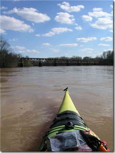
In the weeks and days leading up to the trip the Carolinas received record amounts of rain and the Catawba River was literally raging. There was talk on the news of dams potentially failing up-stream and all the USGS river gauges were showing massive amounts of water coursing throughout the Carolinas. I put off my trip for a couple days waiting for the volume of water coming out of the Lake Wylie Dam to drop. On Saturday, March 22 I finally decided to put in below the Wylie Dam. I roared out into the current at around 1425 and coupled with a 4 mph current I took off down the river.
The first 24 miles were relatively smooth paddling although I kept my distance from the banks which were, of course, littered with sweepers and strainers. There were only a couple mild "riffles" at a few locations. There were plenty of water-birds, turtles and other river wildlife along the route.
With the sun setting I finally reached Landsford Canal State Park and a truly terrifying 10 minute run through the shoals there. The river was running about 25,000 CFS at that point and I'm not a white-water kayaker. I just pointed downstream and paddled as hard as I could. This part of the river worried me for weeks prior and thanks to Andy (Joemess) and Al James (Landsford Canals park ranger and kayaker) I had a bit more information to work with. After plowing through a half-mile of standing waves it was getting dark so I pulled out and made camp. In 4 hours and 15 minutes I had gone 25.55 miles down the Catawba.
 Day 2 I broke camp and was on the river by 0830. It was peaceful and cool with not a cloud in the sky. After a few miles the Catawba dumps into the Fishing Creek Reservoir where I paddled to the planned take-out point just above Fishing Creek Dam. My girlfriend met me at the take-out at 1120 and we grabbed some lunch while she ferried me around all of the dams in that section (Fishing Creek Dam, Great Falls and Dearborn Dams). The put-in was below the Dearborn Dam, which had water topping out over it all the way across. The current below the dam was swift, promising a quick ride. After wolfing down lunch and saying goodbye to my girlfriend I climbed back in the kayak at 1322. A few miles down river and the current slowed as the river gave way to the wide expanse of Lake Wateree.
I made for Lake Wateree State Park where I camped. It is a great park with sites you can literally paddle right up into. I met some nice old folks there that even fed me and it was a relief to set up camp on property I wasn't trespassing on!
Day 3 dawned brilliant and warm. I hit the water at 0915 and the paddle down Lake Wateree started out on glass smooth water and it quickly got hot. Rounding a bend in the lake however, the breeze freshened and soon I was taking whitecaps over the bow, but it was nice to be cooled off. Paddling into the wind definitely slowed up progress however.
I reached the end of Lake Wateree just above the Wateree Dam at 1255 and luckily enough a man with a pick-up truck was fishing at the take-out boat ramp and he was kind enough to give me and all my gear a lift to the put-in below the dam. The Wateree Dam was also topping out and the current below the dam again was very swift. I hit the water again at 1315 and took off like a shot down the river. I was getting pretty sunburned at this point as it was a brilliantly sunny day out but I had forgotten to pack sun-block; a huge mistake.
The current on the Wateree River was steady and I took tons of pictures and video of all the interesting sites along the riverbanks. As it started to get dark I was concerned about finding a campsite since much of the land bordering the river was flooded. I didn't want to get stuck on the river at night though and I finally had to settle on a very forboding looking hunting camp. Just getting ashore at the boat-ramp required me to paddle with all my might against the current just to maintain my position as I angled across into an eddy. I pulled out of the river at 1833 after a days run of 37 miles.
There was a No Trespassing sign posted with a post-script that said "Servivors Will Be Prosecuted" (and yes, that WAS the spelling!). I made camp and barely slept a wink that night and was happy when the birds started singing in the morning. I packed up camp quickly and was on the water as the first grey light of morning hit at 0645. The mist was rising off the water and I saw a couple of deer in the woods and one swam across the river in front of me.
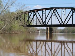 The Wateree River winds sharply through the swamps approaching Camden and my pace was great. I paddled steadily until 1033 when I reached the Highway 76 bridge east of Columbia. I pulled out for some lunch at the flooded boat ramp and was surprised to see another kayaker pull up. His name was Curt Cookie and he was going on a day-paddle. We chatted for awhile and then we both got in our boats and pushed off at 1132.
I was hoping to make Trezevant's Landing to camp at. I had visions of it being a luxury campground much like Lake Wateree State Park was, with showers and food and a safe place to pitch a tent. It was something to look forward to! About 3 or 4 miles above the confluence with the Congaree River the current dropped to zero, which was depressing. I was badly sunburned and overheating despite all the water I was drinking. The only long sleeve clothing I had was a cotton sweatshirt and it was incredibly hot. I had blundered BADLY by not including sunscreen in my supplies.
At 1642 I ran into the Congaree River and never even caught sight of Trezevant's Landing. I assume it was obscured in the woods or something. With darkness coming on I found my campsite for night 4 along the banks of the Congaree. The mileage for the day was a stunning 56.7 miles but I was worn out. My hands were blistered and my skin was very badly burned. I made the decision then to climb a ridge behind my campsite and call for my "extraction" the following day. I left a message on my girlfriends voice-mail and hoped she would meet me at Santee Cooper State Park on Lake Marion.
My campsite for the night was great and I slept soundly. I woke up early on Day 5 and broke camp and was on the water by 0630. The current continued for a few miles until the broad expanse of Lake Marion stretched before me. The lake was a little rough with 1 foot chop but with my destination in sight the paddle was fun. Bald eagle nests dotted the tree stumps in the middle of the lake. At 1000 I reached Santee Coooper State Park and the welcomed sight of my girlfriend waiting for me. Day 5 was a short one with 16.9 miles paddled.
Total distance paddled on the trip was 155.2 miles. Actual on water time was 32 hours and 22 minutes giving an average speed of 4.78 mph. Top speed attained was below the Wateree Dam and that was 10.0 mph.
I was disappointed that I didn't make my ultimate goal, but if you read the full trip report you'll see how my mental state was after a few days on the river. My advice: take a friend, it will keep you sane.
Note - My web-site has photos of the above trip. Additionally I've made about a 40 minute video with music and titles and still pictures that I can send to people if they are interested in viewing it. Just drop me an e-mail at beachav8r@carolina.rr.com
Outfitting:
Thanks to Andy (Joemess), Al James of Landsford Canal State Park, H.R. Hall who's trip report on the Catawba can also be found on this site and served as the inspiration for my trip, Mr. Charles Foster who fed me at Lake Wateree State Park, Mr. William Hoffman for driving me around the Wateree Dam.
Fees:
I think it was $12 for a site at Lake Wateree State Park, the best $12 I ever spent (hot shower!). All other camping was unfortunately, by necessity, on private property, thus I was trespassing (awful feeling). Normally there would be sandbars to camp on. The river was not "normal" by any stretch of the imagination.
Resources:
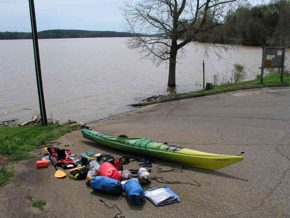
I used printed DeLorme topo maps as reference. Additionally I used a Garmin GPSMap 76 GPS with Garmin Topo software loaded in it. Invaluable as a tool for planning and keeping mileage and speeds.
Trip Details
- Trip Duration: Extended Trip
- Sport/Activity: Kayaking, Canoeing
- Skill Level: Intermediate
- Water Type: River/Creek (Up to Class II)