
Kayaking the Mouth of the Columbia River's Tidal Influences
Paddlers love adventure. We have that in common although our boats, destinations, and encounters may vary widely. What started out as an early spring day paddle on the Columbia River near where I grew up in Washington State found me embarking on a journey that would change my life. My kayak adventure’s purpose became to slow down and explore the Columbia’s beauty. The goal was accomplished after spending several days kayaking at its mouth trying to finally reach the Pacific Ocean. Reading maps, historical accounts, and paddling river stories about the mouth of the Columbia River had still not fully prepared me for what it would feel like in my kayak paddling against wind, tides, and shipping lane traffic.

There are many factors that make the mouth of the Columbia River especially unique. Its volume changes dramatically both daily and seasonally due to the Pacific Ocean tides and the 60 tributaries that feed the Columbia especially when snowpacks melt in the spring. The 1243 miles (2,000 kilometers) it travels, 500 miles of which are in Canada, find it winding through a wide variety of geological and climate zones. In fact, from the Columbia’s headwaters near Canal Flats, BC, it travels almost 200 miles north before turning south and finding its way to the Pacific Ocean. It has the greatest flow of any North American river entering the Pacific. At its formidable mouth, near Astoria, OR, the Columbia is just over four miles wide. References to the “mighty Columbia River” are well earned in this tricky paddling area.
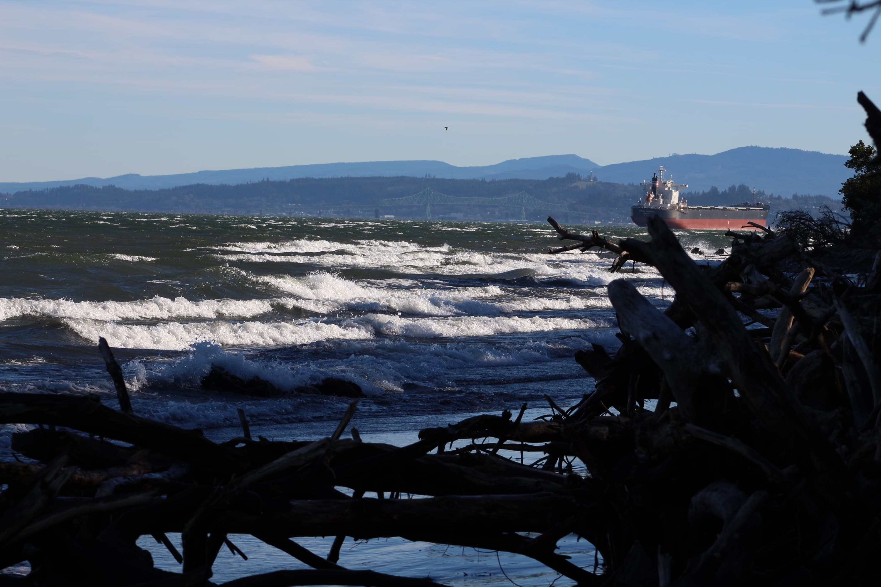
There is little time for relaxing and fishing on this section of the Columbia. However, one of the most helpful maps used for this paddling adventure was ironically a fishing map. Not only did the map show the access roads, boat ramps, towns, river depths, and best places to fish, it showed the shipping channel. Sometimes it is advantageous to paddle where the most current can be found, especially when you are tired in the afternoons from battling the west wind. At other times, it is best to avoid the busiest and most narrow areas of the shipping channel to avoid danger. These massive ocean-going vessels can tower over 120 feet above the water and take up to a quarter of a mile to stop. They run more quietly in the river than one might think and have warning bells for other boats of all sizes.

Local tide charts for Astoria are an essential tool for paddling the mouth of the Columbia. One of the best ways to take advantage of the tidal change is to put in at slack tide to cover more miles and benefit from the outgoing tide at the end of the paddle when fatigue sets in. No matter the direction, you cannot paddle against the high tidal influence in this area. The fast-moving tidal water sweeps around river islands, points, and anything else in its way. The power of this Pacific Ocean tide can be felt as far as 140 miles upriver beyond Portland, OR. Paddling in this area requires careful planning and enhanced safety measures such as carrying a rescue rope throw bag, whistle, dry bags with extra clothes and food, waterproof map, first aid kit, and compass or GPS unit. The fog can set in with no notice as weather fronts approach the Pacific Northwest coastline.
The Columbia River is also unusual as it has no delta. Its mouth is now defined by two enormous jetties and dredging to maintain the shipping channel for cargo traffic to and from ports around the world. After considering whether to take my kayak out on the Washington or Oregon bank based on safety, I selected Clatsop Spit just three miles downriver of the town of Hammond, OR. Since naval exploration began, hundreds of ships have met their doom in this area, and that is why it is now called the Graveyard of the Pacific. The plan was to paddle safely as close to the Pacific Ocean as possible without crossing the treacherous Columbia Bar.
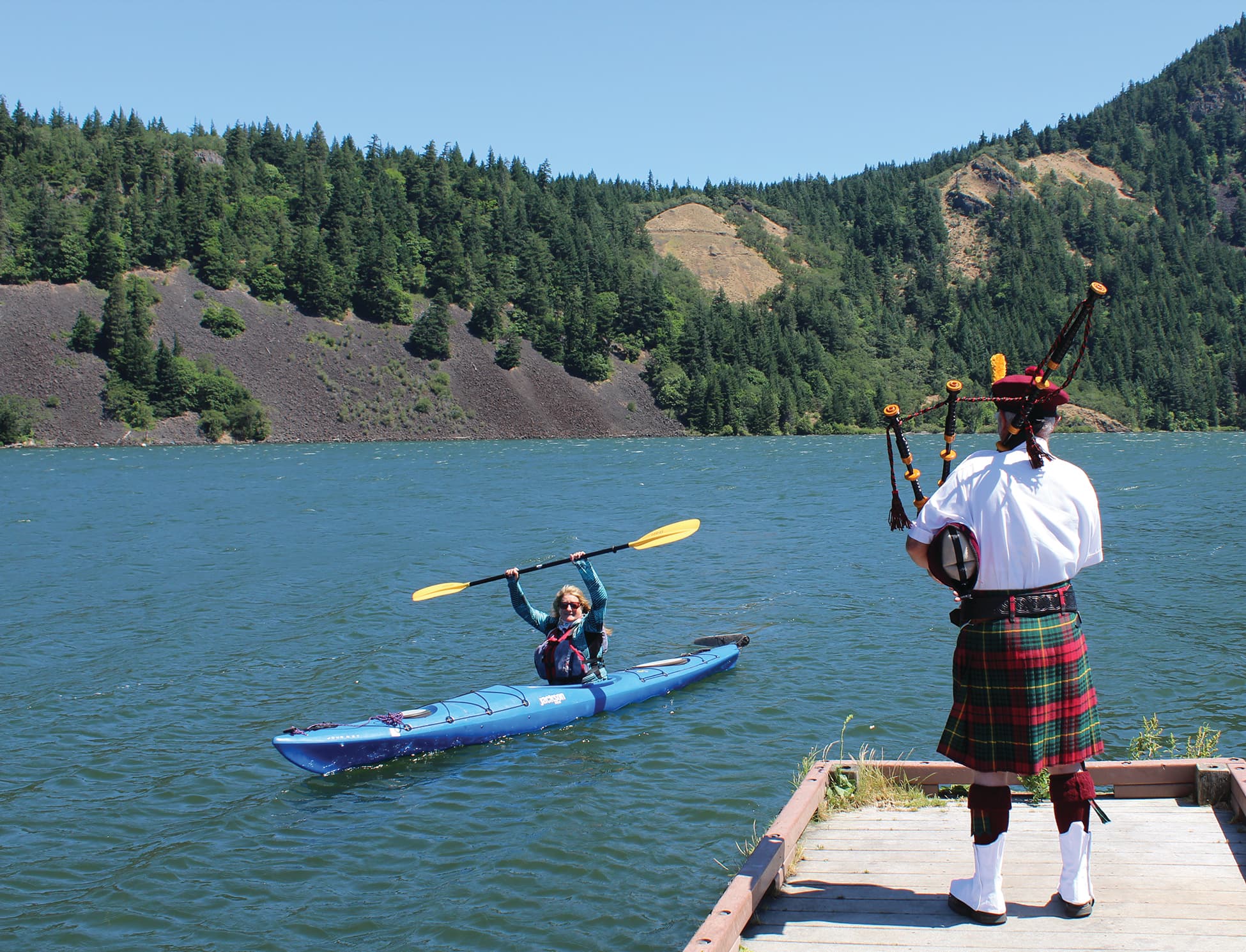
As I approached the end of my retirement paddle adventure down the Columbia River, I reflected on everything it had taken to reach this point. Each paddle had been about 15 miles in length and were not completed in order but when family and friends could join me for a stretch along the way. I started the adventure near where I was born and raised in Goldendale, WA, by putting in just below the John Day Dam. The goal of the journey was to slow down and get to know the Columbia River better after spending most of my life rushing along its side to and from appointments, vacations, and other destinations. Stories from the journey were formed into chapters for my book Paddle to the Pacific which was published in February of 2022.
Paddling the last handful of stretches nearing the Pacific Ocean provided opportunities for further exploration and tenacity. While camping at Skamakowa, WA, in a riverside park, a massive sand dune along the Columbia looked out of place. As I walked the sandy beach, I discovered numerous white oval rocks all along the riverbank. The color looked typical for the area but when I picked up one of the rocks, it weighed almost nothing. Rock after rock slipped into my pockets. Their size varied but they all had the same rounded, relatively smooth appearance. Further research with some locals revealed that the pumice and sand dune had been dredged from the bottom of the Columbia to keep the shipping channel open.
The pumice now filling my pockets had traveled downriver from the 1980 eruption of Mount St. Helens. After drifting down the Toutle River near the volcano and into the Cowlitz River, it would have entered the Columbia River just over 40 miles east of Skamakowa. It had made its own journey down the Columbia River and would finally make it to the Pacific Ocean with me on my kayak adventure.
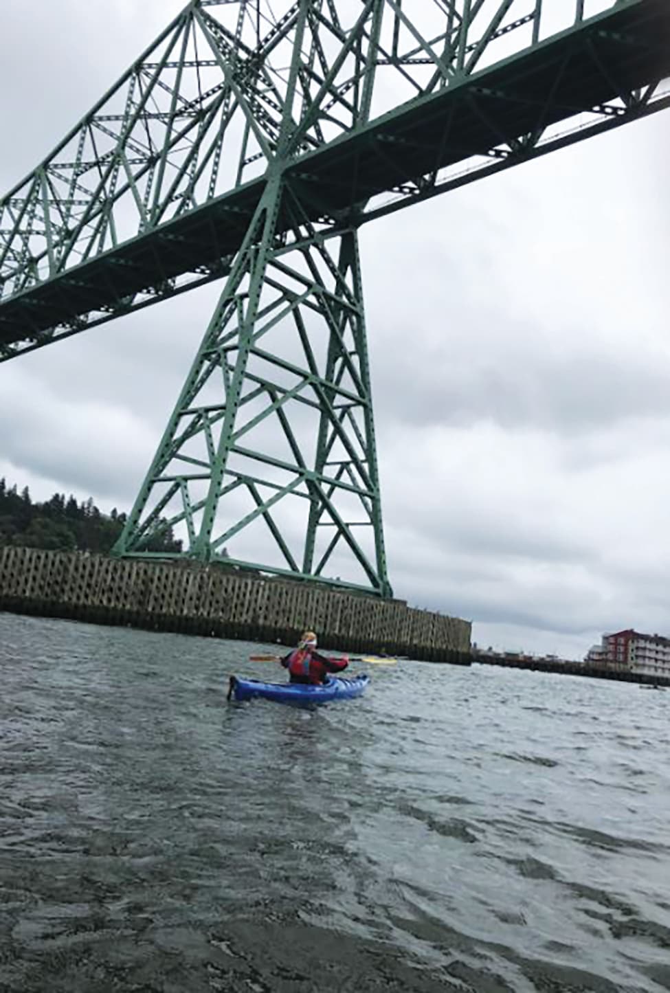
We paddled out from Skamakowa for a river crossing through the Lewis and Clark National Wildlife Refuge. It consists of 27 river islands stretched out over 20 miles and abounds with birds and other wildlife. The Pacific Ocean dream was becoming a reality one paddle stroke at a time. One of the final put ins was at the mouth of a small tributary, the John Day River, just 10 miles east of Astoria. Paddling under the 4-mile-long Astoria-Megler Bridge had been on my bucket list for some time. I enjoy the new perspective of looking up at any bridge from the river. This entire journey had been about slowing down to gain new perspective and it was working. However, extensive planning is sometimes still not enough for a smooth exit.
The outgoing tide just past Astoria was gaining strength as we neared Clatsop Spit. Taking advantage of the fast-moving river and avoiding shipping lane traffic was a thrill, but we went so fast that we missed out predetermined lunch takeout at Warrenton and ended up surprised to be in the next town, Hammond! To make matters worse we had a very narrow miss with a speeding fishing boat entering the marina at Hammond. A tuna boat captain had been working far out in the Pacific and was apparently in a rush to get home. There were four of us kayaking together that day, and my friend was waving her paddle high in the air to be seen by the captain. It suddenly got very crowded at the entrance to the small marina as the fishing boat split through our team, cut the throttle, and almost swamped us with the back wash. After sponging out our kayaks and recovering from the shock, we realized how lucky we had been not to have collided with the speeding boat.
Clatsop Spit was just another three miles down the river and as close to the Pacific Ocean as I wanted to get. As we paddled across the open water of the Jetty Lagoon nearing out take out, the small outline of two people standing on shore waving a us was a welcome sign. However, they weren’t saying hello, our shoreline support team was telling us we had zipped past the planned takeout beach. Once again judging the river current, tide, and changing wind had altered our plan. Happily, we reached Clatsop Spit at last, and my dream of adventure on the Columbia River came true!
If you would like to read more stories from the book Paddle to the Pacific: A journey of reflection on the Columbia River, visit my website at www.paddletothepacific.weebly.com

Related Articles

Now, in this episode, we're going to the land of the Cree, where the great outdoors is more than a…

Via BBC"Plastic being washed up on beaches and hauled up in fishing nets is being recycled and turned…

"A Veteran - whether active duty, retired, National Guard or reserve - is someone who at one point in…

Watch as paddlers like Evan Garcia, Rush Sturges, Gerd Serrasolses and Galen Vlockhausen take some…