
Potomac River / Saint Clements Island in Virginia
Trip Overview
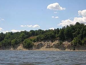
The Potomac River has some surprisingly diverse vistas. The cliffs that line the Potomac in Westmoreland County, Virginia, are a beautiful example. A great place to launch from to view the cliffs is Westmoreland State Park. This well manicured park, with excellent protected beaches charges three dollars as an entrance fee. The best place to launch a kayak a protected beach next to the park's own large quiver of kayaks.
This area of the Potomac is broad and a slight wind generates waves that make paddling a pleasure, removing some of the monotony that is possible when paddling a broad river. A plethora of ospreys feeding chicks in their large nests and large numbers of mature and immature bald eagles that nest along the cliffs make for excellent bird watching. A friend and I started at the launch point and began moving downriver to look at the impressive cliffs. Some of the cliffs are completely sheer and run directly to the water, while some portions have small beaches. I wouldn't recommend landing on any of them, however, since the chances of being hit with falling debris is very high. This is evidenced with many large trees resting at the bottom of the cliffs.
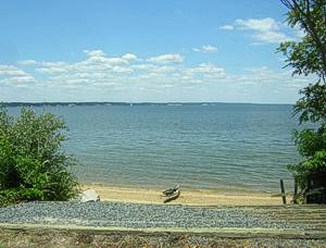 After making an initial survey of some of the cliffs we turned towards the Maryland side of the river to explore Saint Clements Island. Saint Clements is the site of the first landing of Maryland colonists in 1634 and contains a lighthouse, a massive cross commemorating the first Catholic Mass conducted by English colonists in the New World. As we turned towards the island a brisk 19 knot wind caused some fun medium-sized quartering waves that kept us cool by splashing us as we made our way northeast. As we paddled past the mouth of the Wicomico River the chop became larger rollers due to the longer fetch offered by the inflowing river, but even with a good breeze blowing, the waves were easily handle-able.
There were several large sailboats plying the waters as the cross and lighthouse became visible above a small pebble stone beach. We landed and made our way up a decrepit wooden ramp up to the re-built lighthouse and explored the island for a few minutes, which was replete with ospreys, red wing blackbirds and mockingbirds. There are well-equipped bathroom facilities as well as a pier and picnic areas on the island, and it would certainly be a pleasant place to spend an afternoon.
After stretching our legs for a while and reading the various plaques describing the history of the island, we made our way back towards the cliffs, paddling along them and watching the bald eagles fish. This area of the Potomac River bears further exploring and there are several protected coves and beaches reachable only by kayak or canoe that will bring me back to continue kayaking the area.
Accommodations:
The launch point is a protected beach with parking facilities about 20 feet away.
Fees:
$3 entrance fee
Directions:
The launch point is Westmoreland State Park in Montross, VA. The coordinates of the launch point are: 3810'22.62"N, 7652'36.85"W
Resources:
For Garmin files for the trip go to www.brkayak.com.
Trip Details
- Sport/Activity: Kayaking, Canoeing
- Skill Level: Beginner
- Water Type: Open Water/Ocean