
Lumber River in North Carolina
Trip Overview
 We began our journey from Thomasville, NC at 6:00 a.m. Friday, April 29. We drove to Three Bridges Rd, Robeson Co. and left my vehicle-this was to be our take out point for our two day adventure. We then drove to our launch site which was Turnpike Rd, Scotland Co. It was 9:30 when we finally launched on a beautiful day. The crew consisted of just my self and my friend James. We were in my 158 Old Town canoe, loaded down with our camping equipment and enough food for a two day event. It did not take long before we encountered our first of many obstacles-a tree across the river. This was to be a common site for our trip.
We had planned on doing some fishing, but around 12:00 I figured out that we were way behind schedule. The fishing had to be suspended if we were to make the time I had planned. I am used to the open, faster moving waters of the Yadkin, Dan, and the like. This was my first trip to a black water river and I was surprised to see so many trees down. Over the course of our two day trip I estimate that we went over or under at least 75 trees. That is not counting the at least 200 trees we went through where other paddlers and fishermen had sawn out a clear path wide enough to get through.
At 7:30 that evening we had made it to the J.P Stevens Companys water intake. I had originally planned on being at the NC 71 bridge at this time, which was another 7 to 8 miles down stream. We decided to try to make it at least to McGrits Bridge and look for a campsite before dark. We finally reached McGrits Bridge and paddled on for another half mile and found a high, dry bank which had been used by previous paddlers to camp-a perfect site. By now it was just after 8:00. We set up camp, make our dinner of Ramen Noodles boiled with chicken, and went straight to bed.
The next day, we awoke refreshed and made our breakfast of sausage links and not so good scrambled eggs. We hit the water at 7:00 and soon realized that this day was going to be just like the previous. More trees and horseshoe bends. At 11:40, we stopped for lunch at the Alma Rd bridge and decided that we wound do the next section to Recreation Center Road (6.7 miles) and I would try to get a ride to my vehicle since there was no way we could complete the originally scheduled trip.
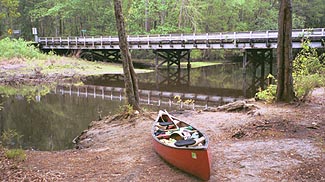
 We reached the Recreation Center Road Bridge at 2:30. It had been raining on us for about 5 minutes, but it really did not matter because at this point it was comical. Fortunately there is an Indian Cultural Center next to this bridge and I found some really nice folks who after I explained our situation, were more that happy to take me to my vehicle. After I returned and picked up my paddling partner and the boat, I took him to his truck back at the launch site and we headed back to our respective homes to a nice soothing shower. I am a bit jealous-he had a steak dinner waiting on him; I had to eat take out pizza!
This trip overall was a great experience. We paddled 37 miles over two days. We saw a red fox, a HUGE owl, woodpeckers, dozens of ducks, signs of beavers and many beautifully colored birds. The trees were beautiful and the weather was great. I should have done more research as far as the time required for this distance, but I will know next time. I am definitely going back to the Lumber River. I would call this river the Amazon of NC.
Directions:
From Thomasville, 109-64-220-74 to Maxton
Resources:
Paddling Eastern North Carolina, Paul Ferguson
Trip Details
- Trip Duration: 2-3 Day Trip
- Sport/Activity: Canoeing
- Skill Level: Beginner
- Water Type: River/Creek (Up to Class II)