
Kings River in Arkansas
Trip Overview
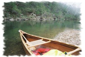
The King's River runs north-south through Northwest Arkansas and empties into Table Rock Lake in Missouri.
We had a great day, leaving from Rockhouse Access traveling 7.7 miles to Trigger Gap and King's River Outfitters who shuttled us back for $20.
The river gauge was reading 3.04 with optimum float level beginning at 3.0, so it was shallow, but very pleasant. We had a couple of drags but not bad enough for me to moan while my strip canoe went through.
The water was about 65 degrees, clean and fresh. Sightseeing was pretty good, bluffs and forest with plenty of fish (trout, bass) to look at.
I recommend this as a good day trip. If you want to float longer, take 2 sections and go to Hwy US 62 and do an overnight on a gravel bar.
Directions:
US 62E to Eureka Springs. South on Carroll County 302 (Rt. turn @ Rockhouse Road)- folllow signs to King's River Outfitters.
Resources:
"A Canoeing & Kayaking Guide to the Ozarks" by Tom Kennon - a really good guide to Ozark whitewater!
Trip Details
- Trip Duration: Day Trip
- Sport/Activity: Kayaking, Canoeing
- Skill Level: Beginner
- Water Type: River/Creek (Up to Class II)