
Buffalo National River in Arkansas
Trip Overview
Buffalo River 2006 Trip Report
By Bill Rowe
Pictures by Julie Luck
 When I received an email from George Lackey, the esteemed voyager from San Angelo, Texas, asking if Id like to join a group planning to paddle the Buffalo River during the first week of May, 2006, I didnt even have to think about the offer. Of course, I would.
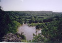
For years I had heard about this 150-mile, undammed, free-flowing stream that Congress designated Americas first National River in 1972. The Buffalo is nestled in the Arkansas Ozarks, originating high in the Boston Mountains and dropping steadily to its confluence with the White River. Its waters flow down to the Arkansas River, then into the Mississippi River, and finally into the Gulf of Mexico. A wide corridor of land adjacent to the Buffalo has been preserved in its natural wilderness state and is administered by the National Park Service.
Our interesting and diverse group of twelve Texas adventurers came from Austin, Boerne, Houston, San Angelo, San Antonio and Tyler; most paddled solo recreational kayaks and there were three tandem canoes. The lineup consisted of the following:
- George Lackey, the trip organizer
- Tom W., "The Tarp Man," a polite farmer who disdained tents and seemed to sleep soundly through thunderstorms wrapped up in a tarp
- Julie L., a quick-witted and cute accountant who was the youngest of the group
- Joline M., the famed organizer of the International Saturday Paddlers of South Texas
- Ed R., a mature Boy Scout who never let us forget how fortunate we were to be "out there"
- Michael P., a financial guru who also knows how to run rapids
- Goldie T., a musician who can play anything, sing anything, and fix anything
- Tom R., a biology professor, writer and birder extraordinaire
- Kathy W. and Debra J., mental health professionals who experienced moments of high anxiety when their canoe unexpectedly collected one of the National Park Services water moccasins--almost in Kathys lap
- Claire L., jovial violinist, bird expert and canoeist;
- Bill R., a veterinarian who kept a record of events of the trip in his daily journal and authored this trip report.
During the weeks and months leading up to our planned trip Northwestern Arkansas had been in a prolonged drought, so there was a lot of uncertainty about whether there would even be enough water in the Buffalo River to float our boats. That drought came to an abrupt end on Saturday, April 29, the day we all arrived in Arkansas. A major storm system moved into the state and began to turn most of its waterways into torrents. We had originally planned to get together as a group and have dinner together Saturday evening in Conway, Arkansas, but the storms delayed several of the travelers. As a result, Ed, George, Joline and Michael ended up at Sims Barbecue in Little Rock where they declare they got the best pork ribs they had even eaten.
After Saturdays deluge we slept that night high and dry in motels in Conway, Arkansas, and awoke the next morning to a beautiful, cool, cloudless day. The fine weather afforded us just the opportunity we had been waiting for to make a side trip over to Toad Suck, Arkansas, for a tour and to check the current prices of wheat straw at the Toad Suck One Stop. Toad Suck is the location of a former ferry crossing on the Arkansas River, and according to folklore the place got its name from the local saloon where travelers and boatmen would drink so much alcohol that they would swell up like toads. Interestingly, there is a huge commingled oak/pecan tree on the site which produces both pecans and acorns. There was some speculation that this oddball tree developed as a result of all the human-processed alcohol that was peed on it behind the saloon in Toad Sucks earlier history, but thats just one of many theories that abound in these parts.
 After our tour of Toad Suck we headed up U.S. 65 via Pickles Gap and through the mountains to Silver Hill, Arkansas, arriving at the outfitters Sunday afternoon right on schedule. We were informed that the river had been closed by order of the National Park Service because of flooding, so we set up camp at Tyler Bend Campground and had the whole place pretty much to ourselves. We decided to stay there until the river was legally open. Sunday night Michael grilled a delicious brisket and served it to everyone along with tortillas, guacamole and a pot-luck assortment of other peoples foods. The feast was so large that we enjoyed the leftovers for several days afterward.
By Monday the river level had subsided some, and "experienced paddlers" (us?) were allowed to put in to make short runs, which we did. George suggested that we make the scenic 5.6-mile trip from Tyler Bend to the village of Gilbert which would ordinarily be a three to four hour float. At river levels that the Park Service considers "high and dangerous" (a bit over 5,000 cfs in this case), we covered that distance in about an hour and fifteen minutes.
Gilbert is a hamlet of about 75 souls with an ancient general store where two big old shaggy dogs slumber on the porch and where river runners can get just about anything they really need, such as river maps, Dr. Peppers and Snickers. Gilbert was once a thriving railroad, timber and ore town until the railroad went away in the 1940s. Gilbert is worth visiting, and there is even a nice little restaurant there if you happen to be in town on the right day and time (we werent).
By mid afternoon we were back in camp after our float and decided to shuttle up to Bakers Ford for the 4.6-mile float back to Tyler Bend. Because of the speed of the river, the shuttle turned out to take much longer than the float trip. This section of the river was beautiful and would have had some good rapids were it not for the high water which covered up the rocks. One of the highlights of the section was a huge sycamore tree serving as a Great Blue Heron rookery where we counted at least 10 noisy nests and numerous heron parents tending to their duties.
There had been much discussion, especially from Joline, about a catfish dinner, but with the fast muddy water there was little chance of catching fish of any kind. Not to be deterred, however, Joline, Michael, Tom W. and Bill drove 35 miles north to Harrison, Arkansas, for some down-home commercially prepared catfish complete with ice cream and cobbler (arent we tough campers?). With more rain predicted (it happened), some of us opted to pack up our dry tents and sleep in our SUVs Monday night. Others elected to stay in their tents or tarps and to ponder whether or not they were going to get electrocuted during the evenings very impressive lightning display.
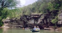 On Tuesday, May 2, we broke the fast, cooked separately, ate together and discussed the weather, the river level and our options for the day. We came to a consensus to do what we had come for; i.e. paddle the river and camp along the way for several days. George arranged for Silver Hill Outfitters to shuttle us upstream to Pruitt, so we hurriedly broke camp and piled ourselves and our gear into the outfitters retired school bus as two of their staff placed our canoes and kayaks onto a trailer. Our wisecracking, nicotine-addicted local driver careened the bus for about an hour and a half around curves and over hills past Dogpatch (yes, there really is a Dogpatch, Arkansas!), to Pruitt Landing where we launched at 12:30 PM to begin our multi-day downriver adventure. Pruitt is 41 miles upstream from Tyler Bend, and the river there was much clearer than it had been downstream; however, it was still high and flowing very swiftly. With very little effort we made 12.2 miles Tuesday afternoon, paddling alongside 400-foot high towering limestone bluffs, surrounded by mountains and forests so lush that it was hard to believe that this area had ever experienced a drought. We noted countless Weidemeyers Admiral Butterflies which are as big as Swallowtails, and we saw countless beaver signs on tree trunks. The bird watchers in the group enjoyed spotting many species of birds and identifying their calls. There was an abundance of wildflowers to remind us that springtime had definitely come to the Ozarks.
When we arrived at the low water bridge at Hastyaka Phillips FordEd gave us some anxious moments as he boldly chose to run it in his kayak. The combination of the 4-foot drop and an impressive river flow level created a powerful hydraulic below the structure. From our restricted viewpoint above the bridge we could only watch and wait for what seemed a very long time before Ed emerged downstream with his boat upright. Unbeknownst to him, he was being pursued about thirty yards behind by a dry bag that had literally been flushed out of his kayak in the hydraulic. Everyone else opted to portage the ford, and Joline later earned "hero points" for the day by being the one who found and retrieved Eds dry bag a long way downstream.
By late afternoon Tuesday we had inspected a lot of sandbars and finally found one that was high and remote, so we landed at about 5:30 PM. After we had prepared our suppers, Michael, Joline and Bill all produced an assortment of chocolates when they put into a "campers mousse." It was delicious, but we needed about a gallon more. We all enjoyed sitting around the campfire while Goldie played her flute. What a life!
No rain fell Tuesday night, but there was very heavy dew Wednesday morning, so once again we packed and loaded soggy tents. Collectively we were sincerely hoping that Wednesday afternoon would prove to be sunny and dry so we could dry out our things before nightfall. After a hearty breakfast we resumed our voyage downstream and very shortly had some non-humorous excitement at the expense of Debra and Kathy. As they paddled over near the bank to survey a rapid, their canoe glided beneath some overhanging branches and suddenly Kathy found herself face to face with a water moccasin hanging from a limb. As her helpful paddling partner, Debra, tried to swat the snake away with her paddle, the thing dropped right into their canoe. At that moment there was a lot of activity in the boat with the two women reportedly moving faster than an Olympic ping pong championship match! We have it on fairly good authority that the frenetic activity was accompanied by a fair amount of high-pitched screaming, but we havent been able to confirm it. With Goldies help they beached their canoe, but they had to completely unload all their gear to get the slithery critter out. We dont know how long it took for Kathys and Debras pulse rates to return to normal.
During the early afternoon on Wednesday we got off the river near Mt. Hersey and hunkered down for about 40 minutes in the bank side willows waiting for a lightning storm to pass over us. The pause gave most folks the chance to take a nice nap using their life preservers as pillows. For a while the sky looked like it might be getting ready to rain all afternoon, but in Camelot-like fashion the clouds cleared out and gave us a beautiful warm and sunny afternoon. Cruising through riffles, we found that the compression waves caused by the high water made spray skirts necessary for the kayakers, whereas the canoe bow paddlers did their duty by catching the ice cold waves in their laps.
 By 4 PM we had set up camp on a sand bar directly across the river from Skull Bluff and sat in the shade relaxing and sharing snacks while enjoying perfect weather conditions. Nearly everybody took the opportunity to swim, bathe, and wash out some clothes in the big swimming hole in front of our campsite. Skull Bluff is named for its resemblance to a human skull and was formed by water that eroded out caves that look like eye sockets. At lower water levels it is possible to paddle boats eerily into one eye socket and out the other. It was a very good day with a few rapids, beautiful wilderness and about 13 miles of river travel. Now we could recline in our camp chairs and watch the vultures circling overhead. Eventually a large hawk joined the vultures soaring above us. Later we were serenaded to sleep by a combination of Goldies flute, distant coyote howls, bubbling water and the calls of whippoorwillsa perfect combination of civilization and wilderness.
During the night there was a succession of thunderstorms with brilliant lightning, roaring thunder and lots of rain. Good tents sure do make camping more comfortable, but during the barrages some of us were still acutely aware that a couple of thin sheets of nylon really arent much protection against 50,000 volts of electricity. When we compared notes the next morning, we learned that several of us had been listening to the water rushing against Skull Bluff during the night and worrying that the sound was that of a river that might be rising and carrying away our boats. Some admitted to unzipping their tents several times during the storms to shine flashlights down to the riverbank and check for rising water; others even got up and went out into the rain to inspect the situation. All those inspections helped us sleep a little bit better, but there were several red-eyed and sleep-deprived folks around camp the next morning.
It rained on and off most of Wednesday night, and the last thunderstorm gave way to a steady rain that lasted from about 7:30 AM to nearly noon, during which time some stayed in their tents eating, snoozing, or reading while others huddled together under Jolines weathered tarp trying to avoid its various drips. There was a short break in the rain at about noontime, so we packed up our wet tents and gear and set off downstream, this time wearing our full rain suits. We observed Green Herons, Great Blue Herons, beavers, turtles, a few swimming snakes, bullfrogs and lots and lots of small birds. All the critters seemed to be enjoying being wet after suffering through the prolonged drought. The river was high and rising because of all the overnight rain, and our boats were propelled at amazing speeds downstream, passing over lots of areas that had probably been rapids before all the rain but which were now just big, splashy compression waves.
Our lead (guide?) boat took us into no less than two fairly long routes that looked pretty good at the top but which ended up in dangerous and essentially impassable willow jungles where they joined the main channels. So, we got our chance for some aerobic workouts paddling about a mile upstream against a formidable current. It took the combined efforts of the whole group to get all the boats back into position and headed downstream again, but everybody kept pretty cool, nobody wrapped or flipped a boat, and there were no injuries. Pilots sometime say that any landing you can walk away from is a good one; so perhaps there is an analogy here. But if you ever paddle the Buffalo River, when you get to Arnold Island dont even think about taking that scenic route around the left side, no matter how tempting it might look.
Even with the upstream paddling and the time spent extricating several boats out of the trees, we still covered the 16.2 miles from Skull Rock to Tyler Bend in a bit less than 5 hours. When we pulled into the Tyler Bend campground ramp we were a bunch of tired, wet, hungry river rats. One of the outfitters employees happened to have been fishing as we floated past before reaching Tyler Bend. He recognized George and offered to come down and transport our drivers to the cars, a serendipitous meeting which greatly benefited us. Thank you, Silver Hill Outfitters! You really are a nice helpful bunch of folks.
At the take out there was a discussion of possible plans for the last day of the scheduled trip, Friday, May 5. The truly hardy folksClaire, Goldie, Julie, and Tom W.--decided to camp overnight and paddle from Gilbert down to South Maumee on Friday . The rest of us (call us the wimpy bunch) succumbed to the lure of hot showers, dry clothes, warm motel rooms and restaurant meals.
Thanks to the unexpectedly high water we enjoyed 9.9 miles of day trips on Monday, May 1 and 41.6 miles of downriver travel and camping Tuesday through Thursday (plus that bonus mile of upstream paddling). Then the hardy group did another 12 miles Friday. There seems to be a consensus that, overall, it was a fun trip on a magnificently beautiful river that would be well worth doing again.
Outfitting:
We used tandem canoes and solo recreational kayaks for our trip. Sprayskirts are recommended for kayaks if the river is high. Heavily loaded boats are not recommended for the section from Ponca to Pruit; consider "leapfrog" daily shuttles and day tripping up there. River levels are completely dependent upon the most recent rainfall, and the watershed drains out very quickly following rains.
Fees:
The National Park Service does not require permits, nor does it charge fees to paddle the Buffalo National River. There are no camping fees unless you stay in one of the developed campsites; sandbar camping is free and is definitely the best way to enjoy this magnificent river. Camping fees at developed NPS campgrounds are very cheap (about $10 per site).
Directions:
To reach Silver Hill, AR from the south, take 1-40 North from Little Rock north to Conway, AR and then take U.S. 65 north.
If you're coming from the north, take U.S. 65 out of Springfield, MO and proceed south to Silver Hill, AR.
Contact:
We used Silver Hill Outfitters in Silver Hill, AR for canoe rentals and shuttles.
silverhill65.com/silverhill.htm, phone: 870-439-2372
snailmail address: Rt. 1, Box 48A, St. Joe, AR 72675
Their service was exemplary, and the prices were very reasonable. We highly recommend them.
Trip Details
- Trip Duration: Extended Trip
- Sport/Activity: Kayaking, Canoeing
- Skill Level: Intermediate
- Water Type: River/Creek (Up to Class II)