
Yadkin River in North Carolina
Trip Overview
 Byron, Joey, Rick and Greg headed out on an overnight paddling trip on a section of the Yadkin River. The plan was to drive to a campsite near Boonville, NC and spend Friday night there so that we could get an early start Saturday morning. From that starting point, we planned to paddle approximately 17 miles to the island campground within Pilot Mountain State Park and spend the night. We would then finish the trip Sunday morning with a 5.5 mile paddle to a take-out point near Donnaha.
Day 1: Friday, Oct 14
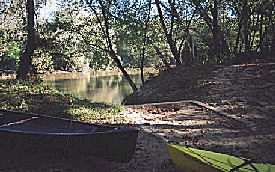
Rick and Greg left downtown Charlotte around 4:30 to meet Byron and Joey at a gas station off of I-77. Traffic was thick from downtown through Huntersville, but we got through it and made it up to Elkin, NC around 6:30. We decided to grab dinner at Wendys, and since Joey needed to pick up a hydration bladder, we checked out the Elkin Wal-Mart. While Joey was in the store, the three of us felt like teenagers again as we cruised the Wal-Mart parking lot waiting for Joey to come out. We made it over to Boonville (5-10 miles away) around 7:30 and found the campsite. The campsite is called Yadkin Shore Access and is privately owned but maintained by the Yadkin Co. Parks & Rec. Call 336-679-4228 for reservations. It was quite muddy due to recent rains, but the idea was to just have a convenient base from which to start Saturday morning. Joey and Greg set up the camp while Byron and Rick shuttled the cars down to the take-out point in Donnaha (this took approx 45 min). We drifted off to sleep to the sound of traffic from the nearby road whizzing by, but knew that tomorrow would be a good day.
Day 2: Saturday, Oct 15
The temperature had dropped into the mid 40s during the night, so we were all a little chilly when we woke up around 7:00. We started off the day with a hearty breakfast of eggs, sausage, mini-bagels and coffee. Once we got all of our gear situated and loaded-up, we shoved off around 10am. This initial stage of the river was very smooth, as water levels were good, the temperature was very pleasant, and we were ready to make some progress down the river. A little past noon, we stopped near Rockford to have lunch, which consisted of PB&J, peanuts, apples, and snack bars. We probably got back on the river around 1:30. The river started to pick up at this point, as we encountered a few tricky rock ledges that required some maneuvering.
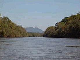
Around mid-afternoon, we finally saw the money shot of the tripa far-off view of Pilot Mountain itself. Its an interesting rock formation, as the top of it is flattened; almost reminiscent of a mushroom. After about another hour of paddling, we took a stretch break along a sandbar. It was good that we stopped to rest here, as the challenging shoals section of the river was coming up next. Although the water levels were decent, we all had some difficulty navigating the shoals. Once we made it through this tough section of river, it was around 4:30pm, and we were upon our stopping point for the daythe island campground at Pilot Mountain State Park. The island itself is approximately a mile long, and is marked by a tall set of concrete stairs leading up from the water. There are two spacious campsites, each with its own picnic table and fire ring. Once we got the boats unloaded and tied-up, we set up camp and relaxed for a while. Everyone freshened-up by taking a quick bath in the (cold) river. We then enjoyed a satisfying dinner of pasta with alfredo sauce topped with shrimp. We would like to point out that the alfredo sauce was made with legal condensed milk. Right after eating, we heard another canoe pulling up on the shore, which happened to be a young couple looking for a last-minute campsite. We helped them unload their boat and learned that they had not planned for a take-out point, so Byron offered to give them and their canoe a ride back to their put-in location the next day. We enjoyed the rest of the evening by the fire, eating cherry fritters and sharing stories.
Day 3: Sunday, Oct 16
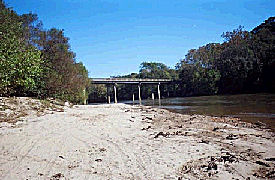
It was even colder during this night than it was on Friday night, as it dipped into the lower 40s. Byron went for morning hike around the island, Greg took a few pictures of the misty water, and we just piddled around camp trying to warm up. Breakfast consisted of coffee, grits, and whatever food was left. After eating, we started to pack up and get ready for departure. Byron checked with our neighbors to see if they wanted to follow us to Donnaha, but they decided to go on their own, so he gave them instructions on how to find the take-out. We finally shoved off around 11am and started the remaining 5.5 miles of the trip. Greg and Rick got hung up on a tricky ledge, but other than that, this final leg of the trip was fairly smooth. We finally made it to the Donnaha take-out point around noon, and found it to be very muddy. Byron retrieved his truck that he had left at a nearby restaurant (leaving a vehicle unattended at night below the Donnaha bridge is not recommended), so once he returned, we loaded everything up and headed back to Boonville to pick up Gregs car (total drive time from Donnaha to Boonville = 25 minutes)
We were all hungry at this point, so we drove to Jordans Country Restaurant near I-77 in Elkin for their Sunday lunch buffet, which consisted of fried chicken, pork chops, mashed potatoes, and veggies. It was a great way to end the trip, and after this we headed back to Charlotte.
Conclusion
Overall, this trip was a great success. Water levels were sufficient, the weather was very pleasant for paddling, and we had a great time just hanging out. This route is definitely recommended for an easy to moderately-difficult overnight paddling trip.
Comments:
Accommodations:
Yadkin Shore access: Primitive drive-up camping; 2 sites with picnic table and fire ring; nearby port-a-john.
Pilot Mountain State Park (island): Paddle-in only (or wade across river from bank). Two campsites, each with picnic table and fire ring. No water or toilet facilities.
Outfitting:
Wilderness Systems kayaks; Old Town canoe
Fees:
No fees required.
Directions:
To Yadkin Shore access: From I-77, take Elkin exit #82 onto NC Hwy 67. Travel approx 5 miles to Boonville. Head north on US 601 toward the river. Look for "Campsite" sign on right immediately before bridge over the river.
Resources:
Yadkin/Pee Dee River Map was very useful for planning and navigation. One can be obtained at http://yadkinrivertrail.org/ or Great Outdoor Provision Company.
Trip Details
- Trip Duration: 2-3 Day Trip
- Sport/Activity: Kayaking, Canoeing
- Skill Level: Intermediate
- Water Type: River/Creek (Up to Class II)