
Voyageurs National Park in Minnesota - Extended Trip Report
Trip Overview
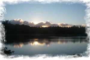 The weather is a crapshoot up there after Labor Day, but we chose to visit the park again after Labor Day due to the lower number of powerboat campers who tend to hog up all the available campsites in the summer.
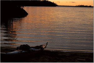
Put in on September 8th late in the evening, to the accompanying rain. The mosquitoes were bad only in that one backwater campsite with lots of swamp water.
1st day, intended to paddle from Ash River area to the extreme East end of Namakan Lake, to put us in striking distance of the Crane Lake area. Reached that end of the lake by late afternoon on Sunday, the 9th.
Next morning, prepared for day trip to Crane Lake, but was met with bad weather report from the other group with us, who had chosen to get off the water a few days early, and didn't want to chance being stuck in that area of lake. So, our plans were immediately changed, and we lost the opportunity to paddle Crane Lake.
Paddled the distance (14 miles or so) back to the Western end of Namakan, landing at Kubel Island large campsite. The following day was a shore day due to high winds (50 MPH gusts).
 Made the obligatory paddle to Kettle Falls for lunch on Wednesday, opting for beer and burgers in the middle of so much wilderness.
The weather turned cold and windy for the next two days, and the short-timers in our group decided to leave us by Wednesday, leaving the rest of us Thursday thru Saturday to explore the area.
Explored Johnson Bay area north of Kubel Island, and made a day trip to Sullivan's Bay to the mouth of Ash River for breakfast at a local establishment. Explored 3-4 miles South on Ash River to the waterfalls.
A great time of year to be in the park if you plan your trip accordingly. Be prepared for rain, snow, sleet, and wind, and most certainly come prepared with a warm sleeping bag. We hit 25 degrees one night up there with high winds.
This was my 2nd trip up there. This time, I realized that you don't necessarily have to camp on designated campsites. There are a lot of unimproved areas with fire rings made out of stone. If you take your time, you can find all sorts of gems along the way... old cabins that are decaying over time, etc.
Fees:
No reservations or feesDirections:
From Duluth, MN, drive North on Hwy 53 and follow the signs to Voyageurs National Park - Ash River StationResources:
Garmin GPS maps for US National ParksMcKenzie maps of Voyageurs National Park
Trip Details
- Skill Level: Intermediate
- Water Type: Flat/Sheltered Water