
Upper Kunjamuk River in New York
Trip Overview
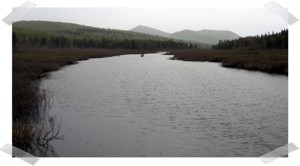
Located in Hamilton County only a couple miles east of Speculator the Kunjamuk River is a small meandering Class I river offering reliable year-round water flow. Paddling upstream on the Kunjamuk River from Big Bay to Elm Lake is a popular ~7 mile round-trip through the former International Paper Company timber land.
We left one vehicle at the parking lot on Route 30 and proceeded up Elm Lake Road traveling across the lease agreement International Paper Company roads. A 4wd high clearance vehicle is recommended. The land in this section was excessively logged about 100 years ago. In the 1930s, the Civilian Conservation Corps came in and created a plantation of pines, mostly scotch and white pines.
We stopped on State Land at the trailhead to Rock and Long Ponds at Cisco Brook (Latitude 43.6047, Longitude -74.3053). This trailhead is on the old Kunjamuk Road which was the major roadway between Speculator and Indian Lake in the 19th century.
 From our launch point on Cisco Brook we encountered the 1st beaver dam/obstacle at roughly 70 yards downstream and began a count of obstacles. For our purposes an obstacle was a beaver dam or, more commonly, a deadfall/strainer that required one or more of the passengers to leave the canoe, pull through using brush or use means other than paddling to gain passage. Using this definition we encountered 31 separate obstacles from Cisco Brook to Elm Lake.
In addition there were 10-12 beaver dams that we were able to slide over or through with vigorous paddling. Just below the fish barrier dam we encountered one of the tallest beaver dams I have seen - close to 4� in height.
We chose mid-May hoping to have adequately high water to ease our passage over obstacles and to avoid biting black flies. With the temperatures in the high 50s the black flies were swarming when we stopped for breaks, but rarely bit and were not a concern while we were paddling.
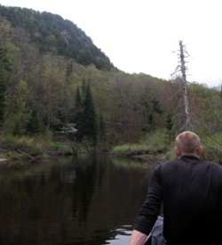 The Kunjamuk is very scenic, offering several views of the rocky outcroppings on Upper Pine Mountains. In fact, more than once the meandering stream caused us to make 180 degree turns and we viewed Upper Pine Mountain from the northern, western, and southern perspectives.
From our last break at the sand pit just south of Elm Lake we paddled out in 40 minutes completing our trip 7 hours 40 minutes after our departure. About 45 minutes were used for lunch and breaks. We estimate that each obstacle took between 3-4 minutes for a total of an 1� to 2 hours on obstacles leaving roughly 5 hours of straight paddling time.
It was one of those "Gee that was memorable. Thanks for inviting me. Let me know the next time you have one of these trips planned and I will try to be busy....."
As documented in the Jessup River Wild Forest Unit Management Plan DEC has the power to regulate use of waters and to regulate uses of rivers such as the Kunjamuk. As the International Paper holdings transfer to DEC stewardship it will be interesting to see if there are efforts to clear out some of the obstacles and make the Kunjamuk more accessible for through paddlers.
Annotated pictures from the trip are at www.TheSwirl.org/trips/Kunjamuk/Kunjamuk.html
Fees:
No
Directions:
Detailed in the report
Resources:
guide books: "Adirondack Canoe Waters: South and West Flow" and "Fun on Flatwater: An Introduction to Adirondack Canoeing"
magazines: (http://www.paddlermagazine.com/)
On-line forums: http://www.adkforum.com/showthread.php?t=4747
Individual websites: http://www.skidmore.edu/~jbeachy/canoe/2005-07-02/kunjamuk.htm
Trip Details
- Sport/Activity: Canoeing
- Skill Level: Advanced
- Water Type: River/Creek (Up to Class II)