
Thompson Creek in Alabama
Trip Overview
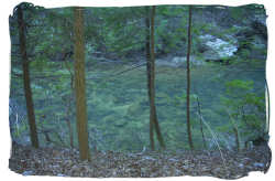 After floating this run once already, it was believed that this creek would have amounted to a reasonably easy shoot. The first time we did Thompson Creek to the Hwy. 60 bridge, the water was not high nor extremely low. It had a decent flow but had about 6 or 7 bad log jams. The previous trip lasted 6 hours. This last run was made after the big rain that occurred on Friday, April 7th 2006 when Haleyville had bad wind and tornado damage. That morning, we saw just how bad it was, Subway's roof ripped off and a line of forest with trees snapped like toothpicks.
We had planned to do this trip for a week and decided not to back out no matter the weather. Early Saturday a.m., checked the online flow gauge and it showed Thompson Creek as "good" while Sipsey was "high." We arrived at the put in and noted the water was moving quite quickly.
To be honest, the creek was more violent than then the Sipsey. The logjams had not gone away, even after 5 weeks. The previous time we saw a Forest Ranger and he asked about the creek's logjams. I explained that the worst was on down from where Hubbard and Thompson flowed together. There is a site where people typically camp, and where the water gets it best. The log that fell across this made the shoot almost dangerous. We went through it then anyway and ended up wet and upside down. On this second trip, we found that the only logjam cleared was that particular one as I explained to the Forest Ranger how dangerous it might be.
Within the first ten minutes of our trip, I got too close to a logjam and the current literally sucked my kayak down under the tree. The rear end went down first then it was over. I held on to my kayak knowing it would be impossible to catch if it got away. It was a cold dunk. It may have reached 63 or 64 degree that a.m. but it quickly got colder throughout the day. After this my buddy, who was floating his first time, became a little unnerved by the trip. It was not until we reached the previously mentioned camp site where the water falls to a class II or III that he got highly concerned. We had to cross over to the right side of the creek and attach ropes to the kayaks to feed them down the rocks and violent water. Right after that, we tried to move on but my buddy got caught in a hydraulic where he eventually tipped and slammed against a house-sized boulder. He wasnt able to push himself and his kayak off of this boulder and was being pressed by the current. The current was so strong! I tried in almost futility to get back up to him. He screamed my name and then I heard a loud crack that sounded about like a lightning strike. He went quiet for about 10 minutes and this worried me. I finally got to a place where I could bank my rig and ran up the trail to make sure he wasnt hurt. He was ok. I yelled at him trying to give directions, told him to flow down to me while holding onto his kayak. We finally got on down the creek, emptying his kayak for the 20th time and about out of energy. We had invested close to 6 or 7 hours in this trip and it was getting colder by the minute. We ran into the most difficult logjams further down. With the water being so high, 10 feet deep in places, and the current so strong - these jams were more a danger than just a hindrance.
Getting in front of a rock or jam means being pinned or pushed or tipped. This trip was not the best because of the obstacles, but it was fun. We both invested close to 9 hours in this trip. Perhaps we were being overly-cautious, but being in control was priority one with a noob on board. This float will average you about 7 hours to run with the logjams considered. I recommend it when the water is clear and not heavily flooded. Makes for a very peaceful day on the waters.
Fees:
None, exception being the parking fee at the Hwy. 60 takeout.No parking fee at the Thompson Creek trailhead parking area.
Directions:
Drive down to the Hwy. 60 Sipsey Rec. area parking area: this was our take-out.Going forward to our put-in, drive past Kinlock Falls, then take first right and drive past the old Aunt Jenny Johnson houseplace. Take the next right off of this road, this where Thompson Creek trailhead sign indicates. Follow road until reaching Thompson Creek trailhead. Park vehicle and put in here.
Trip Details
- Skill Level: Advanced
- Water Type: River/Creek (Up to Class II)