Trip Overview
I was 54 years old when I started this trip in May and finished it at age 56. Two separate trips were done in the Spring and Fall of 2019 and the final trip was in the Spring of 2021. Doing most of this trip solo allows considerable time for self-reflection. It connects you with nature and forces you to deal with the challenges placed in your path. Would I recommend a trip like this? Yes, without hesitation. Do it and make it work! The self-gratification pays an endless amount of dividends for the remainder of your life. It is a life changing experience. But, be sure to plan and incorporate safety in all of your actions.
In May 2019, I started South of M-55 and solo paddled (with my Golden Retriever) to White Birch Campground.
Stayed overnight in their cabin. Total time = 6 hours 45 minutes. Moving time = 4 hours 51 minutes. Distance = 9.97 miles. Many obstacles such as downed trees or log jams.
Paddled from White Birch Campground to a disbursed camping spot just North of Leota and stayed overnight on the riverbank during a mega thunderstorm. I was trying to get to Leota to stay at their motel, but ran out of daylight. The tent I had with me was generous in space, but older. It leaked badly and most everything I had was very wet the next morning. This was the reason that I broke this trip up into two segments, May and September in 2019. Total time = 14 hours 38 minutes. Moving time = 10 hours 59 minutes. Distance = 23.19 miles. Many obstacles such as downed trees or log jams.
I paddled from the disbursed campsite North of Leota to Pine Street Bridge (I believe this is also known as Church Bridge). Total time = 10 hours 43 minutes. Moving time = 8 hours 53 minutes. Distance = 23.49 miles. Many obstacles such as downed trees or log jams.
Had a close call before Pine Street Bridge. It was getting late, close to around 8pm on a May evening. As many times before, I approached a tree that must have fallen the previous Summer since all the leaves were still intact. It extended from my right (the trunk) to the left (large spread of branches). I should have realigned my approach, but I did not. On the left side was plenty of space to pass. However, I did not see the submerged tree pointing upstream waiting for me on the other side. Big mistake friends! I managed to dislodge the canoe as it filled with water. It was 50% filled with water that I emptied on shore. Could have been much worse. A lesson learned, always respect the river and take the needed time to do things right.
In September 2019, better prepared with a rain worthy tent, I resumed the solo trip (with my Golden Retriever) at Pine Street Bridge and stayed overnight just short of M-115 at a cabin in Old Log Resort & Campground. Total time = 7 hours 19 minutes. Moving time = 6 hours 24 minutes. Distance = 17.08 miles. One to two obstacles such as downed trees or log jams.
Continued from M-115 Bridge, from the Old Log Resort & Campground to Evart and stayed at the Evart Riverside Park on the West side of the river using a much better tent. It did not rain! Total time = 8 hours 0 minutes. Moving time = 6 hours 24 minutes. Distance = 17.01 miles. There were no obstacles such as downed trees or log jams.
Finished this portion of the trip from the Evart park/campground to North End park in Big Rapids. Total time = 9 hours 4 minutes. Moving time = 8 hours 24 minutes. Distance = 30.1 miles. There were no obstacles such as downed trees or log jams. This last stretch was the most miles I have ever covered in one day and was fun with all of the rapids, stones, and views.
On several day trips, I have paddled tandem from North End Park in Big Rapids to River's Bend Bluff and further down to the Roger's Pond boat launch. It takes about three hours to do a typical trip from North End Park to River's Bend Bluff. Add another hour to the Roger's Pond Boat Launch.
The river trip continued on May 29, 2021 by skipping all of the dams and ponds and entering the river below the Croton Dam. From their, I paddled with my friend Fred and my Golden Retriever all of the way to Veteran's Park just short of Muskegon Lake. The additional details follow.
Over Memorial Day Weekend in 2021, my friend Fred and I paddled the Muskegon River with my dog Pixie from Croton Dam to Lake Muskegon. Fred paddled in his Kayak while I paddled my We-No-Nah Saranac 15' Royalex canoe. This is a tandem canoe but I reversed it and sat backwards in the bow seat making my position very close to center. We had about 400 pounds of gear and other than the wind in open areas turning the canoe, the current of the river more than made up for it.
We disbursed camped on an island very close to shore on night #1. We had a great first day and night though the temperature dipped down into the high 30's F. This was a glorious day and night outdoors! Total time = 6 hours 7 minutes. Moving time = 5 hours 30 minutes. Distance = 20.4 miles. There were no obstacles such as downed trees or log jams. The YouTube video can be seen in the video list of this post.
For night #2, we disbursed camped on state land in a grassy open area on the riverbank. The second night was warmer with great sleeping weather. The temperature only was a cold as the high 40's F. This was another glorious day and night outdoors! Total time = 7 hours 19 minutes. Moving time = 5 hours 56 minutes. Distance = 17.6 miles. There were no obstacles such as downed trees or log jams.
For day #3, we had some tight paddling in narrower parts of the river. This day was the most tactical paddling portion of the three days maneuvering around many obstacles. This was another glorious day on the river! Total time = 3 hours 52 minutes. Moving time = 3 hours 37 minutes. Distance = 10.1 miles. There were plenty of obstacles such as downed trees or log jams, but none that required portaging of liftovers.
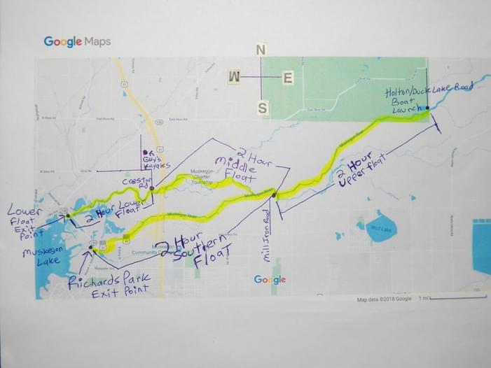
In my research for the portion strating at Croton Dam, paddle times were hard to find. The book "Canoeing Michigan Rivers" by Jerry Dennis & Craig Date provides ranges of times. In most cases, it takes the upper end of what times they provide. What is missing are paddle times between Roger's Pond, Hardy Pond, and Croton Pond. Also missing are times further down river from Maple Island Road Bridge near Bridgeton to Muskegon Lake. There is a map that I included in this post from "Guy's Kayaks" out of Muskegon, MI.
It is the longest river in Michigan and some day, I plan to begin at Houghton Lake and paddle all of the way to Lake Michigan including all of the dam areas. I plan on adding an additional 4-5 days to navigate the reservoirs and rivers up to and in between these dams of Reedsburg, Roger's, Hardy, and Croton.
Safety Notes
Always wear a PFD and let someone know your route and time table for check ins.
Gear Notes
PFD is a must. Consider a GPS locator above M-61 due to the remoteness and cell coverage limitations.
Conditions
Water was higher than normal creating many opportunities to paddle or walk/float around obstacles in low lands.
Portage Notes
No official portages. However, depending on what time of the year, there are numerous trees down and log jams that have to be managed. During the times of these trips, there were between 30-40 where less than ten required going over land and around the obstacles. After M-61, there were no obstructions. This would have been different had I waited until after Memorial Day for the canoe liveries to clear the river above M-61.
Trip Details
-
Trip Dates:
5/23/2019-5/31/2021
-
Sport/Activity:
Canoeing
-
Skill Level:
Intermediate
-
Water Type:
Flat/Sheltered Water, River/Creek (Up to Class II)
- Number of Portages: 30