
St. Mary's River in Georgia - Weekend Trip Report
Trip Overview
 My paddling partner on this trip, Wayne Charles, said once that �the weatherman ruins more canoe trips than the weather� proved to be true. We set out from North Carolina on Thursday during the tropical depression Tammy and headed for Georgia for a three-day, two-night canoe trip on the St. Marys River bordering Florida and Georgia. The St. Mary River starts as the North Prong of the St. Marys running out of the Okefenokee Swamp in Southern Georgia. My brother Denny rode with us on Friday morning in the rain to the put in at Baker County, FL on FL hwy 120, which is the beginning of Section B in the Paddlers Guide to Southern Georgia book. The put in is across the state line and on the right as you go over the bridge. There is a nice trail to the river. This put in is about 5 miles below the start in the paddling guidebook in Moniac, GA. Denny was going to drop us at the bridge and take my truck home to come back and leave it for us at the take out near St. George, GA off GA hwy 94 and Fl hwy 2. When we arrived at the small one lane bridge the rain had stopped. We unloaded the two solo canoes and gear and bid Denny farewell. After loading the canoes we were on and paddling at 0900 Friday. The water gauge listed on the internet was approximately 18 or 19 miles down river, read 400 cfs and height of 6 feet.
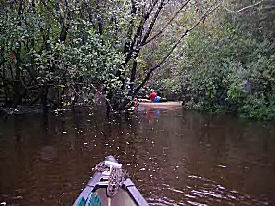
For the first three miles the current had us on our toes as this section is very narrow and you had to maneuver the canoes around the trees in the fast current. At this water level there were still many sandbars and places to stop, which we did for lunch of beanie weenies, and crackers. This is a desolate and pretty section, with hardwood forests, saw palms and pines. After about 10 miles we started seeing houses in a small settlement but it ended before we reached the next bridge. We reached the GA hwy 121/23 bridge after 13.6 miles on my GPS. It was listed in the paddling guidebook as 12.4 miles. This bridge can also be used a put in and take out. We finally found a desolate section and a nice sandbar on river left, Georgia side, after 15.4 miles. We got to this sandbar around 3:30 pm and decided to see how fast the water was rising before setting up the tents. Wayne put his home made gauge out and after about 45 minutes we decided that we were up about 4 ft above the water and would be safe. Wayne moved is gauge two times that night. After setting up camp and snacking on smoked almonds we started the charcoal for a dinner of steaks and salad. That night the water came up 14 inches but we still had room to spare. Breakfast consisted of side meat and a cheese, onion, and pepper omelet and of course, coffee. We lazily packed up and did not get back on the river until 1030.
As we paddled on Saturday, the river began to widen out to about 150 ft and we started seeing a few more houses. We found the gauging station after 18.7 miles total since the trip began. (All mileage will be total from beginning.) We finally stopped for lunch after the settlement ended and we were at a desolate sandbar on the Florida side. A local carrying a bag of deer corn for his feeder came through the woods and waded through a creek near the sandbar. The discussion of interest was if there were alligators. He said that the gators are mostly in the lakes off of the river, however several bends down the river he said one time they caught a 13or 14 foot gator. This was a big sigh of relief, as I did not want to tangle with a 14-foot gator in my 14-foot solo canoe. Or much less, have one come up in the camp at night.
After lunch we paddled on. The river narrowed down to about 40-50 ft. When Wayne and I paddle we do not talk too much or paddle side by side that much either. We had not talked for about an hour and something caught the corner of my eye on the left bank. When I turned my head, a huge 8-foot gator leaped into the water. I said leaped, not slithered, as I have usually seen them do. We must have scared him as much as he scared us. He made a big splash and then crossing the river in front of my canoe he made the water roll like a boomer class submarine just under the surface. No I was too scared to try and find my camera and besides the gator was fast, but Wayne did see it so I have a witness. This was the only gator seen on the trip. We started looking for a campsite around 3:30pm but most of the land on river left was posted and belonged to Spread Oak Plantation and there were some nice campsites. We finally found a little island with not a sign on it. There was a small stream between the island and river left, Georgia side, 29 miles into the trip. We decided that was our home for the night. After setting up camp, gathering firewood, we decided to take a bath. The water was cool and nice to wash off after the sweat-induced fear from the gator that day. Prior to supper we had hors d�oeuvres of summer sausage, gouda cheese, and crackers, and cold beers. That night we fired the charcoal up again for marinated boneless pork chops, and broccoli and cheese. Since the next day, Sunday was Wayne�s birthday (64 if you need to know), I baked him a chocolate chip cake, sans candles, ice cream and happy birthday song. Wayne set his gauge out again that night and by morning the water had come up about 7 or 8 more inches.
The next day, Sunday, we got up fixed coffee, and Wayne cooked country ham and pancakes, which were pretty good despite the fact that he is not a self-proclaimed cook. We packed up and left camp around 0930 headed for the last leg of our journey. The current was strong and we could easily float along about 2 mph without paddling. This section only had a few river cabins and mostly was serene and desolate. We made the take out at the Georgia side of the Hwy 94 bridge and a total of 38.6 miles. The Paddlers Guide to Southern Georgia (copy 1980, second edition 1995) lists the trip as 34.7 miles. This is one of the prettiest rivers I have paddled, mostly desolate with beautiful scenery, not too much trash, and water quality appeared good as there are no major cities or industrial sites on the river. Other than the one gator seen, we saw only one snake, lots of heron, and egrets, and the last night heard numerous owls. Other than the man with the deer corn at our lunch stop we saw one man in a boat with a dog but no one else. After coming back to North Carolina and pulling up the gauging station on the internet, the water came up from Friday to Sunday from six feet to almost 11 feet and a cfs of 400 to 1850 cfs. This was a preliminary run for an upcoming one-week trip in February 06 and yes, I will be back.
Accommodations:
None other than in Folkston, GA
Outfitting:
2 solo canoes, Mad River Guide 14'6" and Old Town Penobscot Solo 15"
Fees:
No fees or permits
Directions:
From Folkston, GA take Hwy 23/121 to St. George, GA then Hwy 94 to Moniac, GA, take hwy 185 South approximately 4 miles to road on left over to FL Hwy 120 in Baker County, FL
Resources:
DeLorme Georgia Atlas and Gazetteer and A Paddlers Guide to Southern Georgia by Bob Schlinger and Don Otey
Trip Details
- Trip Duration: 2-3 Day Trip
- Sport/Activity: Kayaking, Canoeing
- Skill Level: Beginner
- Water Type: River/Creek (Up to Class II)