
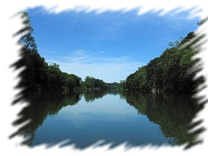
Shenandoah River in Virginia
Trip Overview
My wife and I took Massanutten Adventure's 14 mile canoe trip from Island Ford to the Shenandoah Reservoir on May 23rd. This is a new trip for them and is recommended for experienced paddlers. We were the only people on the trip that day. We spoke with the driver and he said in season they can have over 200 people! We, on the other hand, had the river all to ourselves.
On the day we went, the temperature was in the low 70s with clear skies and light wind. Pretty much perfect - warm enough in the sun to wear as little as you liked, but cool enough to keep the bugs down (or maybe it's just too early in the season for bugs) and not get sweaty. The water was pretty high and only in the 60s - brrr! The river was high enough that there were almost no real rapids on the trip, almost all the rocks were underwater. This made for lots of fun wave trains, though.
About a quarter mile into this trip is the first and longest rapid. The guide suggested we portage around it to the right. We stopped and took a look. I'm not sure how you'd portage around the rapid. It is about 100 yards long, I couldn't see any path through the trees and brush. So we went for it. As I said, the water was high so there were no exposed rocks, but there were lots just below the surface. We bumped and scraped our way through the first section, then settled in for a fun ride through the wave trains. Whee!
There is an island at the top of the rapid, and it looks like going around it to the far left might be a smoother ride, but without being able to see what was back there I took my chances with the long, shallow, bumpy ride (which was more fun, anyway).
After this first rapid, the river winds through farmland and around a big Merck plant. This first half is the most quiet and private part of the trip - the second half has a number of houses along the banks. Much of the land is Merck's and marked with no trespassing signs. Near the end of this section we saw a bald eagle sitting on a dead tree right next to the river. We got within 50 yards and then he swept down and did a turn upriver. Very nice.
Shortly after going under some power lines, on river right, up a steep embankment, is what looks like a picnic area of some sort.
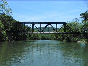 The end of the first half is marked by three bridges in quick succession near Elkton. First is a railroad bridge. River left, just before the bridge, is a park/picnic area. I have no idea who owns it, or what the usage rules are, but it looked like a nice place to stop. (Mass. Adventures did not mention it in the briefing, so I'm guessing it's not public.) Second is a double bridge for Route 33, and finally is a single bridge for the old Route 33.
At this third bridge are steps and a boat slide. Up the steps is a soccer field with a port-a-potty - which was open, clean, and well stocked (so said the wife). The guide said there is a 7-11 on the road here, too, but we didn't check it out. This is where Mass. Adventures starts their 7 mile trip.
Below there the banks get steep, there are houses and cattle on the banks, and there aren't any good places to stop - except maybe one or two. I would recommend taking your time on the first half and enjoying the solitude. We kind of rushed through the first half to make sure we stayed on schedule for our pick-up, but ended up plenty early and I wished we'd lollygagged more in the first half.
The next significant feature is an animal coop of some sort on the right bank. If the wind is blowing upstream, you'll smell it before you see it. If it's blowing downstream, you'll smell it after you see it. If you're lucky, the wind will be from the left and you might not smell it.
After the coop is a nice little rapid and places to stop above and below the rapid. There were people camping here with their trucks and we didn't bother to stop.
 Just before the next set of rapids is another place to stop. There is a creek coming into the river from the left, a flat area, and a dirt road going up into the woods - which are riddled with 4x4 trails. We stopped here for a late-ish lunch. The bridges were too early, and there weren't any other places to stop (except the one already occupied). I recommend stopping at either the park before the railroad bridge or the place that was occupied when we got there, or you could stop at the third bridge and hit the 7-11 if you don't mind the road.
IIRC, this place we stopped is the final rapid of the trip. Below here you get into the backup from the Shenandoah dam. So it is more paddling and really flat water. After this final rapid there are about two more miles to the take-out. It's a good section to just kick back and drift, lie back and snooze in the boat.
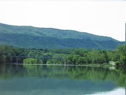
The take-out is at a park by the Shenandoah Reservoir dam. There is a concrete ramp here and ample parking - but I don't remember any bathroom facilities (they may have been there).
An excellent trip and a pretty river. We put in around 10 am and were off the river by 3:30ish. Again, IMHO the first half is the best - if you can handle the first big rapid (which isn't actually big, it's just long and a bit bumpy). There were 11 or so smaller rapids on the trip, again, with most being in the first half.
More Pictures can be seen here:
http://www.panoramio.com/map/
Accommodations:
We stayed at Massanutten Resort. They have timeshare condo units & hotel rooms.
Fees:
$40/person through Massanutten Adventures. None otherwise.
Trip Details
- Sport/Activity: Canoeing
- Skill Level: Beginner
- Water Type: River/Creek (Up to Class II)