
Roanoke River in North Carolina
Trip Overview
When Id first learned about the platforms on the Roanoke/Cashie River system Id planned to camp there this spring. But when my wife Tiff and I decided to move back to New Mexico a few months early I thought Id lost my chance.
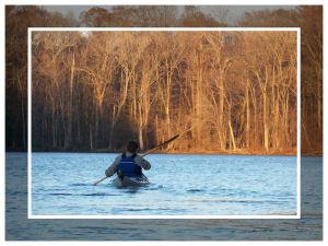
Still, wed ventured into the Great Dismal Swamp for an overnighter a couple weeks earlier and Tiff took my talk about a trip down to North Carolina more seriously than Id expected. So we drove to Jamesville on Saturday and launched from the boat launch just below the Cypress Grill. We talked with a few local people as we readied our gear and were very impressed by their friendlinesstruly the Southern hospitality of lore. When we launched we had a small crowd of curious onlookers wishing us well.
We started later than we had plannedthe sun was settling pretty low as we pushed off. Fortunately we had to paddle less than three miles to Barred Owl Roost. The Roanoke at Jamesville is wide and in no hurry, so paddling up it was pleasant. The trees, stripped completely of leaves, glowed golden brown in the sunset. We turned from the wide-open Roanoke into the still wide Devils Gut. The sun disappeared and color drained from the worldthe sky greyed and lost features; the trunks darkened and shifted to the background to accent dusk. We turned into the Lower Deadwater with barely enough light to see the sign.
I had expected the waterways to narrow considerably once we left the Roanoke, but the Lower Deadwater didnt seem significantly narrower than the Roanoke. In the sparse light we paddled along opposite shores to watch for signs. The slim moon was a spit-out fingernail on the dark sky. We grew nervous paddling in the dark. I paid close attention for any stray sound or bump. My boat scraped over a couple of submerged logs, I narrowly avoided running into a branch sticking up from the water, and once I had to back up to get out of a small cove. We pulled out our headlamps but their short range didnt soothe us much. Fortunately I had written down the latitude and longitude of the platform from the Roanoke River Partners websitea quick check on the GPS confirmed that the platform was close ahead.
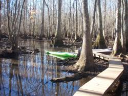 We saw a sign and turned left into a small channel and the trees quickly closed around us as I had expected much earlier. Now especially we had to paddle slowly to avoid obstacles I had to back up again after I wedged my boat on the wrong side of a submerged log. When we wouldnt have been able to go farther we found the landing dock. Tiff and I unloaded our gear and set up camp. We ate dinner and I relaxed, settling into the dark and listening to the owls calls. Their calls still sounded as I settled into sleep.
In full morning light the bare trunks made the forest bleak. Black mud and grey trees crowded all around and left little room for color. The desolation of our surroundings surprised me. I tried to appreciate it as a landscape kindred to the desert I miss and I watched for subtle beauty. Faint grains in stumps and fallen logs, the barks textile surfaces and the waters dark contrast with its bright reflections of the sky. And, especially, the quiet.
After breakfast we packed the boats. Turning the boatsespecially the 17-foot Sea Lionaround in the close trees and shallow water took patience and creative maneuvering. After a few attempts where I succeeded only in grounding my boat or wedging it between logs I finally used a rope from each end, and Tiffs help from her Manitou, to turn my boat around. I climbed in and we paddled away from the platform. Almost immediately the intimacy of the trunks and submerged logs opened into distance as we pulled into the Lower Deadwater. In the daylight we could easily see the well-marked path to the platform.
 The wind was strong but, fortunately, mostly at our backs. Sometimes a gust would hit the side of the boat and I felt like it might tip. But I tried to keep my hips loose and let the boat rock a bit as it needed. We also held our paddles tightly because the wind kept grabbing at them. In only a few minutes we were back in Devils Gut. I crossed from one side to the other looking for some protection from the wind but found little. In only a few more minutes we re-entered the Roanoke. I grew more accustomed to the wind and tried to enjoy the free ride. With light to see and a formidable tailwind our return trip took less than half the time we had taken to paddle in.
I was disappointed to find the Cypress Grill closed as we pulled up to the boat launch I had been looking forward to the famous fish fry. But I should have realized few businesses would be open in this small town on a Sunday morning. We loaded the boats and gear into the truck and drove away from our last trip on the east coast.
Accommodations:
Wooden dock at water's edge connected by wooden walkway to raised wooden camping platform.
Outfitting:
17' Aquaterra Sea Lion
14' Necky Manitou
Fees:
$20 platform reservation fee to Roanoke River Partners
Directions:
We took US 17 down from Virginia, left onto NC 45, right onto US 64 to Jamesville.
Resources:
Roanoke River Partners website: roanokeriverpartners.org/
Trip Details
- Trip Duration: 2-3 Day Trip
- Sport/Activity: Kayaking, Canoeing
- Skill Level: Beginner
- Water Type: River/Creek (Up to Class II)