
Pictured Rocks National Lakeshore in Michigan
Trip Overview
Day 1: Miners Beach
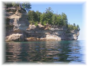
My brother, James, and I haul the last of our gear down from the parking area above Miners Beach and pack and launch our kayaks onto the slate-gray surface of Lake Superior. There is a strong north wind today, throwing waves up onto the beach, so we paddle carefully. We swing eastward and cruise along the high, rocky headlands of Pictured Rocks National Lakeshore, known by old-time Great Lakes sailors as the "Graveyard Coast".
One hundred and forty years ago, ship traffic sailed along this rocky southern shore of Superior, heavy-laden with their cargoes of mining equipment and raw copper and iron ore. So many of those ships were lost in fog, struck unseen reefs, or were thrown up here against the towering cliffs by violent north gales that this dangerous stretch of shoreline came to be known by its macabre moniker. We are mindful of this reputation today as we angle along the cliffs and make our way eastward.
About an hour after launching, the wind shifts to the northeast and gains strength. Though entranced by the namesake 'painted' cliffs and the numerous sea caves, we must admire them from afar today, as we find ourselves distracted and kept offshore by the rough conditions. The wind drives waves onto the sheer rock faces and into the caves, which boom and echo with the force. Clapotiswaves reflected back off the cliffs to form chaotic and spiky watermakes the paddling difficult near shore, so we angle out, tuck down, and make our way along beyond the surf zone.
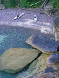
By mid-afternoon we finally round Grand Portal Point and swing into a sandy bay with the idyllic name of Chapel Beach. We land the kayaks in dumping surf and pull up on the sand beach, then begin lugging our camping gear up the dunes to our site in the woods.
It is remarkably sheltered here, with only the whispering treetops to remind us of the wind we struggled against all day on the lake. After rigging a clothesline to dry our wet paddling gear, we settle in and enjoy dinner as the sun sets behind the cliffs on Lake Superior.
Daily distance: 7 miles
 Day 2: Chapel Beach
The morning dawns cool, with glass-calm conditions on Superior. The water laps gently at the sand, and undulates in barely perceptible swells out to the horizon with a liquid calmness I have never seen on this lake before. It is with a barely-contained sense of anticipation that we make a quick breakfast, break camp, and launch onto the placid, blue-green water.
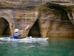
We swing west today, and although we are backtracking, it is like exploring an entirely different stretch of shore. Without the waves of yesterday threatening to drive us onto the rocks, we are free to poke our kayaks into every sea cave and beneath each rocky overhanging arch. We glide along the namesake 'pictured rocks', the towering two-hundred-foot cliffs 'painted' by the weathered and oxidized minerals leaching from the layered stone. Despite the calm conditionsor perhaps because of themit seems to take us twice as long to cover the same mere seven miles as yesterday, as we pause here and there to take photos or to simply gaze in wonder at the sculpted cliffs.
We stop for lunch at Mosquito Beach (fortunately a misnomer today), then continue past Miner's Beach and cruise below the picturesque Miner's Castle. Almost exactly five months ago to the day, one of the distinctive stone turrets of Miner's Castle broke apart and fell into Lake Superior, forever altering a local landmark and reminding all that nature is a forever-changing force. And warning paddlers to steer clear of potential rockfalls.
We head southwest along the tall cliffs and as we come around a point we hear the unique cry of an eagle high atop the stone wall, followed by another from straight ahead. Glancing forward, we see the second eagle headed directly toward us, winging low above the water. As the great bird looms closer and closer, her sheer majesty paralyzing my camera hand, we see that she has a large lake trout clutched in her talons, still wriggling to break free.
Just off the next bulge in the shoreline, we check our compasses, swing out, and head west-northwest. Our charts show a few campsites on the eastern shore of Grand Island, only about a mile and a half distant, and we buckle down for the crossing. Now a designated National Recreation Area, and part of the Hiawatha National Forest, Grand Island is an offshore gem of paddling, hiking, and camping.
Near the middle of the passage we can make out indistinct human forms moving on the shoreline, suggesting the campsites are occupied. So we alter our course northward and land at a small sheltered cobblestone beach. There is no campsite here, approved or otherwise, so we paddle up along the thumb of Trout Point for another mile or so and find a lovely secluded site nestled into a rocky cove on the northwest tip of the point.
Making camp, we eat dinner and then hang our bear bags on the provided pole. That night we stretch out on the broad flat rocks, still warm from the day's sun, to watch a brilliant Milky Way churn around the dark sky overhead, sip a few lukewarm beers, and listen to the gentle lapping of the water at our feet.
Daily distance: 12 miles
 Day 3: Trout Point
We break camp and hit the water in good conditions. We take our time backtracking south again along the east shore of Grand Island, exploring a few large sea caves, their walls 'painted' like those of the Pictured Rocks on the mainland. A south wind kicks up, blowing about ten knots, but the waves do not build.
As most of the highly sought mineral deposits in the region lay along the southern shore of Superior, the early ships that carried them sailed along this coast. Though the shortest route to eastern markets, this passage often subjected these 'coasters' to the notorious northerly winds that sometimes screamed across the lake's surface, and offered few safe harbors between the long stretches of treacherous, rocky shore. Munising's large bay, additionally protected by the hulk of Grand Island at its mouth, was a refuge of safety for any laker captain eager to pull his ship from the teeth of a Superior storm.
We paddle around the south end of Wick Point and into Murray Bay. There are a handful of shipwrecks in this shallow harbor, including that of the two-masted schooner, the Bermuda, the ship that sank twice. She still slumbers today in about 25 feet of water, sometimes visible from the surface. Though we glide over the submerged timbers and steam boilers of several other wrecks, we cannot see the Bermuda under the overcast skies.
Unlike the previous campsites, there is no bear pole here so we spend an inordinate amount of time chucking rocks and rope at one another over various tree limbs, as we try to rig a decent bear bag to discourage midnight visits from the local bruins. The NOAA weather radio predicts high winds for our return to the mainland tomorrow, so we hit the sack early to get a timely start in the morning.
Daily distance: 6 miles
Day 4: Murray Bay
In order to beat the winds today, we quickly prepare breakfast, break camp, and load the kayaks.
We hit the water and, true to the NOAA forecast, round the point to face a strong 25-knot south wind. With only three miles of fetch in the lee of the Munising mainland, the waves haven't been whipped up yet, but the stiff wind slows our progress. We tuck down and dig in, our loaded boats nosing into the wind until we round Wick Point and swing southeast. We take the wind and the short waves broadside for another mile or so until we reach the Grand Island East Channel lighthouse, then strike out due east for the mile-wide crossing to Sand Point on the mainland.
Once in the lee of the cliffs of the Pictured Rocks, we are sheltered from the strong winds, and we pause to catch our breath and have a mid-morning snack while afloat. There are more sea caves and painted walls here, and it is only another couple miles back up along the coast to our landing on Miner's Beach.
In only a few short paddling days, we've been humbled by ancient, towering painted cliffs, inspired by the flight of the eagle, and retraced an historic shipping route. Most importantly though, Lake Superior has seen fit to spare us an eternity in the vast underwater tomb of her "Graveyard Coast". With a couple of sweep strokes, we come about and whistle eastward.
Daily distance: 7 miles
Total trip distance: 32 miles
For the complete version of this travelogue, and additional photos from this kayak trip, please visit:
http://www.AquaDynology.com/Passages/picturedrocks1.html
Accommodations:
Pictured Rocks National Lakeshore offers drive-in camping at Little Beaver Lake, Twelvemile Beach, and Hurricane River Campgrounds. Campsites provide a picnic table, fire grate, and tent pad. Solar-powered wells provide water. Vault toilets are available. Camping is on a first-come, first-serve basis (no reservations) with an overnight fee of $14 with lakeside sites at Twelvemile Beach Campground $16/night.
There are also several motels and lodges in nearby Munising, MI.
Fees:
Backcountry Camping: All backpackers and kayakers camping overnight in the lakeshore must obtain a backcountry permit. A user fee of $5 per person, per night is paid when you obtain your permit. Backcountry reservations are possible, but must be made at least 14 days in advance. The reservation fee is $15. Cash, check, Visa, and MasterCard cards are accepted.
Drive-In Camping: Campers staying at one of the Lakeshore's three drive-in campgrounds will pay $14 per night. Lakeside sites at Twelvemile Beach Campground are $16 per night. Sorry, no reservations.
Directions:
Pictured Rocks National Lakeshore is located on the south shore of Lake Superior in Michigan's Upper Peninsula, between the communities of Munising (west) and Grand Marais (east).
Michigan state highways M-28 and M-94 lead to Munising.
State highway M-77 leads to Grand Marais.
Alger County Road H-58 and other spur roads (some unpaved) provide access throughout the lakeshore.
Resources:
"Guide to Sea Kayaking on Lakes Superior & Michigan: The Best Day Trips and Tours" by: William Newman et al
Trip Details
- Trip Duration: Extended Trip
- Sport/Activity: Kayaking, Canoeing
- Skill Level: Advanced
- Water Type: Flat/Sheltered Water