
Ochlockonee River in Florida - Weekend Trip Report
Trip Overview
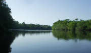
Lower Ochlockonee River

Three friends and I headed from Jacksonville for a three day paddle on the Lower Ochlockonee River near Tallahassee. We had looked at doing a number of rivers in the area, but the water levels were generally very low. The Lower Ochlockonee level is controlled by the dam on Lake Talquin, so we thought we�d have a better chance here. It turned out that with the rain we had earlier in the week that levels were back to their mean, so we had plenty of flow.
We started at SR 20, west of Tallahassee and planned to end at Wood Lake. We launched at the Lazy Daze boat launch. This turned out to be a good place sine we were able to launch all four kayaks and park the car there for only a $3.00 fee. We had gotten there around 11:00, but shuttle the car to Wood Lake and back took 1 � hours, so we didn�t get on the water until 1:00.
 The river is bounded on one side by the Apalachicola National Forest and there is little development on the other bank, so you quickly get the impression of being remote. The first part of the river is fairly straight, but then starts making some sharp bends. Even though the river was quite high, we were able to find some very nice sand beaches to stop and eat lunch and stretch. It was a gorgeous day and a very pleasant paddle. There were a tremendous number of fish, mainly gar surfacing on the river as well as lots of birds. We followed bald eagles for quite a way along the river. There were many turtles and although a few gators were seen at the beginning of the trip we saw very few for the rest of the day.
About 15 miles from SR 20 is Piney Creek, our camping spot for the night. There is only a boat ramp there with a lawn area where tents can be pitched, but no other services. That was OK for us since there was really no other place we saw to camp in the previous 5 miles of river. We were the only ones there until 1:30 AM when a family came and launched their boat, only to return an hour later and haul it back out. There were at least four species of owls that also kept us company during the night.
The next morning we were on the river a little after 8:00 with the mists rising all around us. This was a 19 mile day, but the river was very different here, narrowing and having many more bends that required so tricky navigation. It was clear that if the water level had been considerably lower our way would have been much tougher. Many willows overhung the river and there were no convenient places to stop until we reached a private ramp with a few houses at the FR 13 bridge. This was the only bridge on the whole trip. Past here the river also has side sloughs and �lakes�, which sometimes confuse the route or access to campsites.
We were heading for Mack Landing that was on one of these lakes for our next campsite, but when we looked for the entrance to the lake, it looked too overgrown to be the right one, so we continued on. It turned out that that was it, but fortunately Robert�s Landing was only a mile further.
Robert�s landing is a private ramp and camp and at one time been a vacation cabin site and many of the abandoned cabins are still on the property. Mr. Roberts let us camp on a large lawn area. There was a nice wash house, fresh water and a large picnic pavilion. There was a 50th High School Reunion going on when we got there and the group was gracious enough to invite us over to their fish fry. This hospitality was greatly welcomed and the food was great. By evening we had the place to ourselves. Again we were very happy to find Roberts since there were no campsites that we had passed in the previous ten miles.
 We had a 12 mile paddle planned for our last day and since we had to drive back to Jacksonville got on the water before 8:00. The river started with many bends as the day before, but soon the river opened up into wide long straight sections. We expected to see lots of motorboats here, but we passed none. The weather was again gorgeous and we even had a wind to our backs. We sensed that there was some tidal impact here, but we were making about 4.6 mph and even faster when the wind. I had a GPS with me and was able to tell when we were approaching Wood Lake. This was good since we made such good time we were there much earlier than planned and Wood Lake is also accessed of one of the increasingly frequent lakes on the river. After asking a fisherman or two we were directed to the ramp and were soon on our way.
The group agreed that this was one of the best paddles we had done.
Accommodations:
Lazy Daze ramp at SR 20 was a convenient launching point and place to park the car.
Wood Lake has primitive camping and pit toilets.
Outfitting:
2 - 17' Sea Kayaks
2 - 12' Sit on tops
Fees:
There was a $3.00 fee to launch 4 kayaks and park the car for three days at Lazy Daze.
There was a $5/person tent camping fee at Roberts Landing.
Directions:
> From Tallahassee, travel west for 22 miles on S.R. 20 to the bridge across the Ochlockonee River. There is access on the east side of the river from privately owned boat ramps.
Resources:
A great discription of the trip can be found in "A Canoeing and Kayaking Guide to the Streams of Florida, Volume 1, North Central Peninsula and Panhandle" by Elizabeth Carter and John Pierce.
Trip Details
- Trip Duration: Day Trip
- Sport/Activity: Kayaking
- Skill Level: Beginner
- Water Type: River/Creek (Up to Class II)