
North Fork Tyger River in South Carolina
Trip Overview
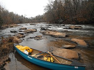
I paddled the last 4 miles of the North Tyger River before it merges with the South Tyger and continued another 4 miles to the takeout at Old Hills Road bridge.
The put-in is at Morris Bridge Road just off I-26. This is a fun and scenic trip down a Piedmont river with smooth stretches interspersed with pretty significant boulder drops.
There are about 5 major drops consisting of tight technical boulder fields that can be tricky at low flows (350-600cfs on the USGS Tyger at Delta gage) and big waves and holes at anything higher. Each of the drops range from 8 to 13 feet vertical over 30-150 horizontal so they are pretty fun for sure.
 The last drop just before the takeout had no real feasible slots to shoot through. Its like human pinball in a canoe. This happens to be the route used during the "Tame the Tyger" annual canoe/kayak race every April.
This was a very nice run of just under 8 miles that has only about 4 homes visible and one bridge (Hwy 50) about halfway down. I ran it at 420cfs on the Delta gauge which means the put-in flow is about half that on the North Fork. This flow is close to minimum to make a fluid trip but at this level the water is pretty clear. Anything over 500 cfs and the water gets pretty muddy.
Fees:
No
Directions:
From I-26 take exit 34 and go east 1/4 mile to Price House Rd. Go about 4 miles passing over the South Tyger then take a right on Hobbyville Rd where it curves left and turns into Morris Bridge Rd that takes you to the put-in.
For the take-out, go west from exit 34 (Walnut Creek Rd) west about a mile and turn right on Shaw Rd. Take Shaw about 4 miles to a left on Old Hills Rd that takes you to the Bridge which is full of unfriendly noo parking/trespassing signs. Leave shuttle vehicles at put-in
Resources:
Delorme and Garmin Dakota 20 GPS
Trip Details
- Trip Duration: Day Trip
- Sport/Activity: Kayaking, Canoeing
- Skill Level: Intermediate
- Water Type: River/Creek (Up to Class II)