
Namekagon River in Wisconsin - Weekend Trip Report
Trip Overview
Namekagon River part of the St. Croix National Riverway
My daughter and I put in at the County K landing north of Spooner, Wisconsin on Friday June 26th at 4:15 PM. The first day was great. The water levels were adequate. We saw two men fishing as we pushed off, but after that we did not see another person until 10:15AM on Saturday. We saw many animals on Friday evening. There were many fish (carp mainly), deer, and many birds including bald eagles. The county K landing is at mile mark N31.2 on the Namekagon River. We wanted to set up camp, make supper, and get settled early so we paddled until the camping site at N25.3.
This camping site was very nice because of the picnic table. It is a group site so it has a picnic table. If you camp at a site that is not a group site there is only a fire pit and a pit toilet. Group camp sites have the luxury of a picnic table. This site was in an area of mature pine trees with some birch and some hard woods mixed in. The tent pads were level and it was easy to pull the kayaks out of the water. The first night out is always Hobo potatoes and hamburgers. There was a deer at our camp site that would not go away and came within 20 feet of us even when we were talking. I use a bear bag instead of hanging my food and I the bear bag has never disappointed. That night at 3:38 AM there was a large animal sniffing my tent and then my daughter's tent. My adrenalin was flowing. The food was nothing was disturbed except my confidence. That night at about 4:30AM it started raining and did not stop until 10:30 AM.
We decided to get going in the rain because there was not thunder. We had dry bags along but the tents, tarp, and us were very wet even with rain coats on. After about 4 miles of paddling in the rain we heard thunder so we pulled off the river for a little while at mile marker N21.3 which is the Whispering Pines landing. The whole trip we averaged a little better than 4 river miles per hour so it was now 10AM. We ate lunch at Howell Landing N16.9. We also picked up water here. There were many people using this landing as a camp ground. As we were eating lunch we watched two men and a young boy load their rented canoe for a fishing and camping trip.
As we paddled in the rain that morning we kind of decided to paddle all the way to Riverside Landing which is our take out point. We just thought everything was so wet and a 30 mile paddle will test our resolve. We were going to stop and stretch our legs at the McDowell Bridge Landing N11.2, but there was a group that was putting in so we paddled by.
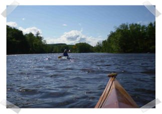
After the McDowell Bridge Landing we passed a group of seven canoeists. The river was very navigable at that point and it was not too difficult. The only mishap was one of the inexperienced canoeist nudged my daughters kayak, but there were no problems due to the fact that my daughter handles her kayak very well.
Our next stop was at camp site N6.2. That was going to be our camp site if we stayed one more night. We decided to push on. About 35 minutes later we got hit by a massive rain shower again and this confirmed out resolve to paddle on. Two miles before the N6.2 camp site we passed another group of paddlers. This time there were five canoes in the group. We did not see any animals until after we passed this group.
 Along the way we saw at least a dozen eagles both mature and immature, many deer, an osprey, a beaver, and a bear.
The one negative when we paddled this stretch of river was the water level at the confluence with the St Croix River. About a mile before the confluence were some nasty riffles that tested my patience due to the fact I was paddling a wooden kayak. After the confluence we were now on the St Croix River and only 4 miles from our take out. This was where the sun finally came out it was about 4:30PM. The St. Croix River is very different form the Namekagon River. The Namekagon River is not real far across in most areas. At the confluence the St Croix River is about 6 to 8 times as wide as the Namekagon River. It is also very shallow and more rocky. At one point I thought I heard a crack on my wooden kayak. We found the main channel about 15 minutes later and my daughter lead the way in the poly kayak and told me about water conditions. About 1.5 miles before our take out we got to an area marked on the map as rapids. These rapids are not difficult, but the wind had kicked up and it was hard to tell if we were going over rapids or white caps. The rapids are easy to paddle through, but some of the rocks are huge and some skill it required.
We took out at the Riverside landing which had many people camping that night at 5:38PM.
The Namekagon (rhymes with "toboggan") River is a river that is wonderful to paddle. The water is clear and we saw very little litter. The camp sites are marked on the map and with little signs along the river with the mile mark on the sign. I understand there is good fishing with a wide variety of fish available. What a gift the Lord gave us.
Accommodations:
Rustic camping (Fire pit, Pit toilets and some sites have a picnic table)
Outfitting:
Old Town Adventure XL 160
Shearwater Boats Merganser 17
Fees:
No
Directions:
North of Spooner, WI about 10 miles on County K
Resources:
I used the St. Croix National Scenic Waterway website for tons of information and maps.
Maps - http://www.nps.gov/sacn/planyourvisit/maps.htm
Home - http://www.nps.gov/sacn/
I also used satellite maps from Google.
Trip Details
- Trip Duration: 2-3 Day Trip
- Sport/Activity: Kayaking, Canoeing
- Skill Level: Intermediate
- Water Type: River/Creek (Up to Class II)