
Loxahatchee Nat. Wildlife Refuge in Florida
Trip Overview
ination Report
Nearest City: Boynton Beach, FL
Difficulty: Easy
Submitted by: Kim Detore

Description:
This pristine wilderness consists of 147.392 acres and is located in western Palm Beach County. Known as the Arthur R. Marshall Loxahatchee National Wildlife Refuge this 221 square mile area of the river of grass boast having more American alligators than any other area within the everglades region. Also known for the tall dense strands of Sawgrass which play host to the indigenous Apple snail which is the primary food source for the endangered Snail Kite, this area is world renown amongst avid birders. Other birds sought after here are the Smooth-billed Ani, Limpkin, Bald Eagle and numerous migratory birds. Also commonly seen are turtles, snakes, deer, otters, bobcats, etc. The everglades are a host to numerous fish species as well, including Largemouth bass, Warmouth, Bluegill, etc.
 When you arrive you might stop at the visitor center and watch one of the many films offered in their auditorium. A boardwalk thru the cypress swamp awaits you out back and then maybe its off to the marsh trail.
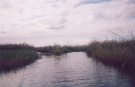
Oh no, its not time to leave yet. You just haven't seen the true everglades until you have paddled or perhaps poled yourself around the 5.5 mile canoe trail. The trailhead is located at the end of Lee Rd. next to the boat ramp area. That's right, power boats with the exclusion of airboats (a.k.a. BLOWBOATS) are permitted to utilize the 57 mile perimeter canal. However the canoe trail is off limits to motorized craft. You will start down the trail after first crossing two p.v.c. weed barriers constructed to keep out exotic floating vegetation. After padl'n or pol'n (as we say it down south) the first quarter of a mile you will come to the fork at which time you will make the choice to follow the direction of the arrow to the right or be a rebel and go left. If you choose to go right the directive arrows will lead you to numerous interpretive signs along the way and guess what! The arrows will continue to lead you in the right direction. One way or the other the trail is man made and with the exception of extreme high water levels it is nearly impossible to get lost as the trail becomes a loop at the fork. Caution, a person or two have in fact missed the exit at the fork and are now labeled "DOUBLE LOOPERS".
At present there is only one stopping point approximately half way around the trail. Oh yes, civilization at its finest, a Port-O-Let on a floating platform. No honey, we can't camp here tonight but I did hear a rumor that in the near future the refuge does have plans to extend the canoe trail and install a camping platform contingent upon the pending lease renewal.
 Oh yeah, I don't want to bore you with all the politics of the refuge but I feel it a civic responsibility to let you know the fifty year lease that was in effect between the South Florida Water Management District and the U.S. Fish and Wildlife Service expired and has only been extended for one year while pending opposition from public interest groups i.e. blowboaters,poachers. The Dept. of the Interior owns only a small percentage of the refuge while the larger portion is owned by the state of Florida and managed under the jurisdiction of the S.F.W.M.D.
At this point in this political quest there is no certainty which way the wind might blow. But one fact remains, if the blowboaters and poachers are allowed back in the refuge the rest of the frogs will disappear, the deer will once again be constantly on the run, the vegetation will be flattened creating unnatural trails and allowing nutrient laden water to penetrate the interior allowing already problematic exotic vegetation to flourish. So if you wish to enjoy the peace and tranquility of this majestic wetland hurry and get here before the invasion.
Accommodations:
Visitors center, Restrooms, Trails, Picknicing is not encouraged on N.W.Refuges therefore we suggest you prepare your needs before arrival as no food is available on site.
Numerous hotels, restraunts, and campgrounds nearby.
Fees:
Daily pass - $5.00 - (per carload)
Federal duck stamp - $15.00 - (annual)
Refuge specific pass - $12.00 - (annual)
Golden age pass - $10.00 - (lifetime)
Golden eagle pass - $65.00 - (annual)
(all prices subject to change without notice)
Directions:
Boynton Beach Blvd. west to S.R.7/411 south 3 miles to Lee Rd. west to refuge.
Contact:
WWW.ECOFLORIDAMAG.COM/ARCHIVED/LOXAHATCHEE.HTM
Resources:
The Everglades River OF Grass
Audubon Society Field Guide To Florida
Refuge maps available upon arrival to refuge or by calling (561)734-8303
Trip Details
- Trip Duration: Day Trip
- Sport/Activity: Kayaking
- Skill Level: Beginner
- Water Type: Flat/Sheltered Water