
Little Miami River in Ohio
Trip Overview
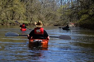
Me and some friends decided to take advantage of the beautiful 70 degree and sunny spring weather and kayak the Little Miami River for the first time this year. The water temps were around 59 degrees which isn't hateful for early spring. The gauge at Spring Valley was running right at 5 ft. 4ft is about normal this time of year.
We put on the river at the public access on 725 near the state route 42 intersection. Our take out point for this trip was roughly 9 miles downstream at the covered bridge (Caesars Creek Public Access point) on Middletown road. We didn't put on the river until 2:30pm and the trip took us 5 hours without any real stops.
This is an easy to moderate trip. Much of this trip is on parts of the river that are not maintained by the canoe liveries. There are some dangers along the way to be avoided like log jams and strainers.
There is the Corwin Low-water Dam that needs to be portaged. We chose to avoid this by taking the side creek about 150 yards before the dam. There didn't appear to be any easy way to portage the dam and since the water was up about a foot the side creek looked like a good alternative.
It's narrow and there were many log jams along the way but it was actually quite a bit of fun. There was only one spot where I got out to clear a few branches to allow the rest of the group to get thru. All the other obstacles were passable without exiting your boat.
 There is a little waterfall / rapid on this creek that was a lot of fun. When you see the old Dutchman restaurant that burnt years ago on the right you know your close to the rapid. About a mile past the rapid the creek rejoins the main channel of the river and it's smooth sailing the rest of the way to the covered bridge.
This is a nice fun trip. The next time out I will scout the low water dam and see if there is a better way around it.
Disclaimer on the side-creek: It was very doable at the water level and day I paddled it. It may not be the right choice on another day if conditions have changed.
Fees:
None
Directions:
Go north on state route 42 north of Waynesville, Ohio about 6 miles. Turn left on state route 725. The access point is about 200 yards on your left.
The take out point is south of Waynesville. Go south on 42 from Waynesville and turn left on North Waynesville Rd. At the first stop sign turn left at the covered bridge. The access point parking lot is just across the bridge on the left.
Launches:
Trip Details
- Trip Duration: Day Trip
- Sport/Activity: Kayaking, Canoeing
- Skill Level: Intermediate
- Water Type: River/Creek (Up to Class II)