
Lake Erie Islands in Ohio
Trip Overview

This is my fifth year of kayaking and, while I hope to have many multi-day trips in my future, I want to take advantage of every opportunity that presents on the water.
I recently paddled and camped with three others and a guide, in level 4 conditions in the Apostle Islands. On another day, a friend and I day paddled from Marblehead, out to, around, and back from Kelly's Island. That was fun and challenging and, in talking about other Lake Erie paddles, I mentioned I wanted to "paddle to Canada" someday.
A couple weeks later, my friend mentioned there were three days of predicted excellent conditions coming up, so we decided to head to Pelee Island. The plan was to paddle out, camp one night; circumnavigate the island the next day, camp again the second night; then head back on the third day.
My recent Lake Superior excursion taught me to take less and pack better. I took just one set of paddling clothes and one set of camp clothes, but I also took: a wetsuit, dry top, rain jacket and pants, and a set of "warm" clothing (in case there was an abrupt change in the weather); 10 quart dromedary filled with water, water purifier, cooking/eating kit, and real food; tent, sleeping bag, small pillow, Therm-a-rest air pad, and camp chair; repair kit (for anything on board AND the boat); well-stocked first aid kit; and a few other items, including a Jetboil Zip which I hastily purchased on the drive to the launch site so I could enjoy hot meals and morning coffee. I could have done the trip with far less, but my planning includes the "what ifs" and, if I have space in the boat, it all goes.
We plotted our course the previous day using a nautical chart, but since the weather was clear and sunny, we could also have simply chosen points on the next island and paddled, correcting as needed.
The Mazurik Access Area is located on the north side of Marblehead Peninsula just west of Lakeside. There is direct access to Lake Erie via a concrete boat ramp into a protected boat bay/safe harbor. The site is open 24/7; it has plenty of paved/lighted parking and Port-a Potties. Besides being 5 miles from Kellys Island, it is 7 miles south of South Bass Island.

We put in at Mazurik's around 1:30 in the afternoon, in full sun, with an air temperature of 85 degrees and water temp of 72 degrees. We headed 30 degrees due north toward Carpenter's Point, which is visible as the far west point of Kellys Island. If you head for the two trees on the Point, then follow the shoreline another mile, you reach a small cove tucked in next to a long old dock. This is a small, pebble-covered beach area, where we put in for a few minutes continuing on to Middle Island, 30 degrees and five more miles due north.
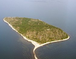 Middle Island forms part of the province of Ontario, is the southernmost point of land in Canada, and is part of Point Pelee National Park. During Prohibition, the island was a rest stop for rum-runners. There was once a hotel, airstrip and mansion on the island, and all but one of the buildings have collapsed and been overgrown with vegetation. The remains of the last structure are still intact, but the hike in through the vegetation and dung was not on our tour. The island is now a nature preserve, and not officially opens to visitors. The cormorants seem to be the main inhabitants right now, and their dung covers every exposed surface of the island including the trees, many of which may already be dead as a result. We put in on the western gravel spit, a good walk from the woods. The closer you get to the wooded area, the worse the stench, but we ventured a walk to the posted sign which provides some island information. The island is home to six species of waterbirds and visitors were prohibited during nesting season from March through August. Black flies are also visitors to the island, and swatting them, while trying to re-launch was a full-time job. Enormous limestone slabs lie beneath the water on both sides of this narrow surface spit, so caution not to drag over them is needed now that the lake water level is low.
Three more miles of paddling 30 degrees north, across crystal clear water, brought us to the south end of Pelee Island and a beautiful stretch of uninhabited beach. This is the far south part of Fish Point Provincial Nature Preserve. The southwestern tip of the island is anywhere from one to two miles long, and juts straight out into the lake, or curves gently around to the southeast, depending on weather conditions over a period of time. This day Fish Point's sand and dunes extended into a long, sweeping arc, gracefully curving nearly two miles from south to northeast. Choosing to camp at the widest point of the sand spit, we found an abundance of dry wood strewn from the woods to the water. As we relaxed, between the flat water on the east and the waves coming in from the west, the sun began its slow descent, and we were treated to one of the most spectacular sunsets of the summer. At one point the colors of the sky and water blended into the same orangey pinks.
We covered 13 miles on Day 1 of the trip, with nearly flat water, 5-10 kt winds from the south/southwest. Moving at 4.5-5.2 mph, it was a rare easy trip across.
Day 2 started with a good breakfast, then breaking camp and packing the gear again. The water remained calm as we put in on the east side of the sand spit. Heading out across South Bay, our first stop was Mill Point. As with each spot we put in, we walked the beach, checked out the locals (if any), and got our bearings relative to other Lake Erie islands. Though not as large as those on Kellys Island, Pelee's own glacial grooves are nearby. The gentle winds were from the east.
 From Mill Point, we headed straight north. This eastern side of the island has many shallow areas and large limestone formations were often just inches below the water. Extra care was needed to avoid boat damage. We passed by the East Park Campground and two public beaches as we kept on course toward Lighthouse Point Nature Preserve. The lighthouse was built in 1833, making it the second oldest Canadian lighthouse on Lake Erie. It was built to help ships through the hazardous Pelee Passage. Though it was restored in 2000, it is closed to visitors. Behind the lighthouse is a trail to a beautiful marsh ("Lake Henry") where you may find herons, egrets, ducks, gulls, and cormorants. There are other walking trails in the area. While we were there, several visitors on foot, and a couple with bicycles, made the trek to the lighthouse via the beach.
Passing by the small landing at Scudder Dock, we headed southwest around Sheridan Point and on to West Dock. The water and wind were still in our favor, but this day we paddled slower, taking in the points of interest along the shore. We were treated to a "te te" between a Cooper hawk and a Sharp shinned hawk (identifying differences between the two) as well as a fly-over by a bald eagle. Human-habitated places were quiet and, except for tourists and locals in town, we saw less than five people as we made our way around the island.
West Dock is the "center" of town on Pelee Island, the largest island in Lake Erie and the southernmost populated point in Canada. According to the 2011 census, the permanent population is 171 residents, but that can swell to over 1,500 during the summer months. We pulled our kayaks in on a beach, a bit away from the dock activity, but a very short walk to the center of town. Actually the entire "town" part of Pelee consists of around six restaurants/eateries and maybe half a dozen other businesses. Since the season ended a couple weeks ago, not much was happening. The ferry MV Jiimaan continues to run between Pelee and Kingsville.
If an island has a restaurant, I like to check it out and have lunch with the locals. We stopped in at the Westview Restaurant, the first place we saw. As we ate, we watched the ferry pull in to dock and watched several people we saw at the lighthouse boarding. Several large trucks, used to carry supplies to the island were also lining up to return to Ontario. Island life has to be expensive when everything has to be "imported". I chatted with the owner of the restaurant, as well as with a couple wed seen at the lighthouse. After lunch we hung around town, taking picture and people-watching.
Soon we were paddling again, completing the last four miles of our circumnavigation of Pelee Island. Still, conditions remained calm. I had been listening to NOAA weather radio since wed left Marblehead, so I knew that would be changing the next day. For now, though, it was back to last's night beautiful beach.
Night 2 was not a repeat of the previous camping experience. The black flies were beyond anything I had experienced. We put in the same place we had the previous evening, but the flies were relentless, so we decided to move farther south, away from any vegetation. I walked my kayak several hundred yards through waist-high water along shore, pulled it up on the beach, and quickly determined the new site had as many flies, less firewood, and nothing to use to weigh down the tent spikes in the sand.
With nothing gained by moving the camp site, we made a return trip through the water (flies don't bite under water); to the same place we'd just left. Here, the wood was already set for a fire, as we'd left it that morning. Setting up camp was a hellacious experience, as every move to do so was interrupted by a barrage of fly slapping and running into the water to get them off. Once my tent was up, I noticed the flies preferred the two sides in the shade, and congregated there by the hundreds. I stayed in the setting sun.
This was not an evening for cooking. Still sated from the late lunch, we snacked on fruit and protein bars. The amazing sunset of the day before was not repeated, but we had no complaints. Sitting on a beach next to a blazing campfire, watching the western skys smoldering glow fade, even as the eastern sky behind us was darkening to reveal a full moon, was a little surreal. Its easy to forget that our universe holds this much serenity and beauty.
We covered 24 miles on Day 2 of the trip, again with nearly flat water and 5-10 kt winds from the south. Paddling speed varied from 3.0 to 4.5 mph.
Day 3 came very early. I awoke about 3:30 Friday to the sound of waves crashing on the beach. I immediately listened to a weather report and the storm I'd been tracking was not going to veer off in another direction. Along with high wind which now came from the southwest, and the prediction of even higher waves coming through our area Friday afternoon, a gale warning was posted for Friday evening. I got up to check my boat. The sand was wet almost to the stern, so the wave height was increasing. I went back to sleep, but again pulled the boat higher at 4:30.
After a quick breakfast, I began packing and loaded my boat in the dark, knowing we had to get on the water as soon as we had enough light. (While prepared to paddle in the dark if necessary, it is always dangerous, and NOAA's forecast assured me that we were okay with time.) The wind and waves continued to pick up.
Waiting for dawn, we enjoyed another campfire before finally departing at 7:30am. We considered putting in on the east side of our sand spit, which was not affected by wind or waves, then paddling around the farthest point before setting our course for Middle Island. Wanting the shortest trip possible, so we instead launched into 2-3 foot surf and set a course at 210 degrees due south.
Between Pelee and Middle Islands, the lake got pretty rough, with waves coming from more than one direction, not uncommon in Lake Erie. Barely maintaining 2.5-3 mph for those first three miles, I elected not to rest on Middle Island. Instead, I continued to Kellys Island while starting to work on improving my forward stroke. Between Middle and Kellys Islands, a stronger south wind and 3-4 foot rolling waves, provided a welcome change from the relatively calm conditions up to that point. This particular stretch of water (between Middle and Kellys Islands) is open to whatever comes across Lake Erie from the south. Paddling south, until this point, protection is afforded by Middle and South Bass Islands to the west. Maintaining a speed of 4.5-5.2 mph across five miles to Kellys, the change in conditions was invigorating.
Speed doesn't always matter, but my concern for the weather was foremost in my mind. I was considering Plans B and C as I paddled. While resting at the cove on Kellys Island, if either my body or the weather told me I would not make it back to Mazurik's before things got bad, I would have either (B) stayed on Kellys for the duration (maybe two days) or (C) gotten my boat to the main dock and come back on the ferry.
Once we got to the cove near Carpenter's Point, walked around and then did some yoga, mind and body were ready for the final crossing and NOAA weather reported we had plenty of time. So, with Marbleheads middle water tower in site, we paddled the last five miles to Mazurik's under cloudy skies, with 2-3 foot waves, and wind still coming from the south. Arriving at the take out, with 52 miles behind us, we already knew where our next Lake Erie adventure.
ADDITIONAL NOTES:
The western basin of Lake Erie is quite shallow, so waves tend to be steep with a short fetch. Though we did not have to deal with any ferry traffic toward Ohio from the islands, we did have to consider the ferry from Pelee Island to the Canadian mainland. We did not present our passports, but they should be carried for a paddle to a Canadian island.
Accommodations:
EAST PARK CAMPGROUND - Open May 1 - Nov. 5, 2012
Located on the east side of the island with 25 individual sites. The sites are wooded and the public East Beach is steps away. NOTE: ALL FEES ARE SUBJECT TO HST
- $20/night per campsite (maximum 5 campers). $5 extra per person.
- Group Rate (open area camping) - $5 per person (for-profit rate).
- Group Rate (open area camping) - $3 per person (non-profit rate, proof required).
GENERAL INFORMATION
- Campground accommodates tents or tent trailers.
- No sites are electric.
- Camping sites are on a first come first serve basis upon arrival. No specific site will be reserved.
- Failure to show for your reservation will result in a charge of one night. A 24 hour cancellation policy is in effect.
- Washroom and shower facilities.
- Family campground-no alcohol (strictly enforced).
- Individuals must be 18 unless accompanied by an adult.
- There is an 11:00pm noise curfew.
- The campground is across the road from the public beach.
- Firewood is NOT to be brought to the island. You can purchase firewood at the campground.
- Fires are to be lit in designated pits only.
Reservations can be made by calling 519-724-2200 from11:00 am to 7:00 pm. A credit card is required to make a reservation.
ANCHOR AND WHEEL FAMILY CAMPGROUND
11 West Shore Road
Located on the North Shore of the island with sites for tents and camper trailers with electrical hook-ups. Washroom and shower facilities.
Rooms: Waterfront Cottage Rentals & Camping. Call (519) 724-2195 for reservations.
There is another "sanctioned" campsite on the east side of the island, but no information could be located at this time.
Outfitting:
Sea kayaks, typical navigation equipment, charts, compass, GPS, bug spray
Directions:
Mazurik State Access Area is about a 90 minute drive west from Cleveland. Using a GPS or GoogleMaps, get directions to:
8957 North Shore Rd in Marblehead, OH
Resources:
NOAA chart for the Erie Islands
Trip Details
- Trip Duration: 2-3 Day Trip
- Sport/Activity: Kayaking
- Skill Level: Intermediate
- Water Type: Flat/Sheltered Water