
Channel Islands in California
Trip Overview
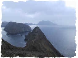
When I first thought about kayaking the Channel Islands (off the coast of Santa Barbara / Ventura in California), I hit the maps. Immediately, it made sense that one could put together a great trip by "island hopping" from San Miguel Island to Santa Rosa to Santa Cruz to Anacapa, and then to the mainland. All of the distances were kayakable, and from the pictures in the National Park Service Map, it looked like a beautiful place.
We immediately started designing the trip, using information gleaned from the internet, and in a short time, we were pretty disappointed. We soon found that the campgrounds are not in convenient locations for kayakers, not all of the islands have potable water, landing is prohibited on most beaches on each island, weather can be very dangerous for any small craft (especially) near the outer islands, and... We couldn't find a report of anyone who had ever done it before. This left us a little discouraged.
We decided not to give up, and continued making plans by internet research and phone calls. We wished that we had some sort of guide where we could find out everything we needed to know in one place. No such guide exists (to our knowledge), and so I decided to make one after I returned home. During the trip, we learned many things that would be useful to people who want to plan a similar expedition to the four main Channel Islands. We also found out that people (though not many) have done similar trips before. In fact, a staff member from Island Packers named Jimmy had paddled out to, around, and back from this chain of islands twice! We were appreciative to have his advice during our travels.

Above is a map out the route we eventually took while paddling the chain of the four main Channel Islands. The Red paddle route is created from our GPS track while kayaking. I drew the green and blue routes in by hand using Photoshop. The green route is not accurate (since Island Packers took us to Scorpion Cove and Becher's Landing on the way out). I didn't draw that in because it would have looked too confusing. As you can see from the map, we did not paddle the entire chain - but now that we have more knowledge of the islands, we are certain that it could be done (discussion on that later).
The best source for kayaking information (other than this report) is the National Parks Page of Kayaking the Channel Islands. There is a lot of information on the National Parks Page, and I don't plan to repeat it. I would like to use this report to elaborate on the NPS information, and give specific information for people who wish to island hop, rather than just do short tours on the individual islands.
Unless you want to paddle out and back, the first thing you will need to do when planning your trip is to arrange for transport to the islands. If you just want to go "the easy way" (i.e. downwind) I'd suggest taking an Island Packers Boat out to San Miguel, and paddle your way West to East with the prevailing Northwesterly. We were very impressed with the service and staff of Island Packers. Their trips out to the islands are not just basic transportation - they also bring along a naturalist who describes and educates over a loud speaker during the journey. Also, depending on conditions, they will take time to stop for wild-life viewing (we saw tons of common dolphins right up alongside the boat)! They also will stop for whale viewing (They even went a few miles out of the way to scout out whales since they had extra time). Also, if conditions are good, they will spend some time exploring the coastline of the islands (yes, they ventured almost as close to shore as we would in our kayak). They took us a good ways into painted cave when we were going from Santa Rosa Island to Santa Cruz Island. I doubt we would have gone much further into the cave with our kayak! We found their prices to be very reasonable considering the service - and yes, they took great care of our fiberglass kayak. I've read negative reports elsewhere - but we thought they were very careful with our possessions. Alex, one of the Island Packers staff, was kind enough to take pity on me (I threw up on the trip out to San Miguel due to the heavy seas) and he gave me a pack of motion sickness pills. Those pills were the one thing we forgot to bring on this trip, and they made a huge difference in the quality of our trip! Thank you Alex!
 The next thing the National Park Service wants you to do (once you have transport to the islands) is reserve your camping. This ended up being the worst part of our trip (though it wasn't too bad). The NPS charges a $13.65 cancellation fee for any campsite reservation that you change in addition to the standard $15 per site reservation fee. I thought that they would be flexible with our reservations given that we were kayaking - and scheduled around the weather mostly. This was not the case - when I called the main line to change a reservation, the operator was very rude, and made it a hassle to exchange just one day of reservations.
Fortunately, we discovered that the rangers on the individual islands are not so strict about the reservations. For example, we were delayed a day on our way from Santa Cruz to Anacapa. We had paid for a night on Anacapa - but were still at Santa Cruz. The ranger let us use our Anacapa reservation for Santa Cruz. No fees, paperwork, or headaches. This should work for you if the campgrounds aren't full - but if they are, you might have a problem. Another option is to make your reservations on the fly. We found that the old Analog cell phones (but not modern GSM types) work from locations as far as San Miguel Island (North side only). The reason for this is the higher transmission power available to these types of phones. Unfortunately, cell phone providers are trying to phase out these phones so they don't have to maintain the analogue towers. You can also contact the Park Rangers via VHF 16 and arrange your camp day-of. Keep in mind, this will only work if the camps aren't full.
One thing that confused us was Backcountry vs. Campground camping. The Channel Islands operates 4 campgrounds on the main islands (see red dots on map below). These campgrounds cost $15 per night. You are also allowed to do "beach" or "backcountry" camping for free - but you make the reservation separately. To make a backcountry or beach reservation, you will need to call (805)658-5711. Below, I have made a map which I hope clarifies the camping situation.

The red dots on the map are the only places you are allowed to camp. Even without knowing the scale, you can tell that it's a pretty long way from that red dot on Santa Rosa (Bechers bay campground) to the Blue Dot on Santa Cruz Island (Del Norte Campground). Also to get to that Blue Dot on Santa Cruz called "Del Norte," you will have to hike a hilly 4 mile route! It's about 27 miles of paddling from the Santa Rosa Campground in Becher's Bay. For most people, this is too much mileage - especially considering the possibility of encountering bad weather during that long time on the water. Plus, who wants to hike in their gear for 4 miles over steep hills - probably without a backpack? I don't know many kayakers who want to stow backpacking backpacks in their hatches!
The Western 75% of Santa Cruz Island is owned by the Nature Conservancy, and they do not open camping on any of this land to the public. You can get a permit for landing on their property for highly restricted day use if you needed a break, but no overnight. I tried to cajole a friend of mine to pull some strings at the Nature Conservancy (he works for them), but nothing ever came of it. Because of the distance and our uncertainty about the weather, we did not paddle this section. Now that we have seen the landscape (via an Island Packers boat), we now feel confident that we could have paddled this section.
The first good landing on the North Side is Cueva Valdez. After that (working your way East), there are a number of good harbors with easy beach landings (Lady's Harbor, Diablo, Fry's, and Twin Harbors). We noted that some of these landings would be very good even in dicey weather. On the South end of Santa Cruz island (Usually in the lee of the winds Northwesterly) there are also a number of good places to land. On the day we went out via Island Packers, the seas between Ventura and Santa Cruz were choppy with 4 ft wind waves. On the South Side of the island, the water was glass. If you decide to paddle this section, you will need to be able to paddle the distance - or somehow make special arrangements with the TNC (good luck).
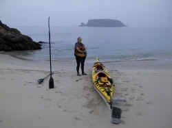
Once you have figured out the above details, the rest of the paddle should be pretty standard. We decided to go in September (After Labor Day) to get the best weather. Average wind speeds are lower (but not much) during September. Basically, you have to wait to get good weather. Depending on your experience level, that might be a while. We allocated 14 days for the trip, and we were lucky enough to have good weather during most of our paddles.
 So, which islands are the best to see? When I spoke with Bill Faulkner - the helpful park ranger at the Ventura location (805) 658-5734, his voice sweetened when he spoke of San Miguel Island. He said you could easily spend 3 or 4 days on that island alone. During the planning, and even when we first arrived, I was quite shocked that one could think so highly of this island. Janet and I initially thought it was like prison (you can't hike the trails unless you are accompanied by a ranger). Since the rangers were "in-transition" on our first day, all we could do was hang out in camp. Our attitude quickly changed, though - and after the trip, we both feel that San Miguel was the most awesome experience of the whole vacation. For one thing, the restricted travel on the island forced us to do what we came here to do - relax! Once we got into "vacation mode," this site became very appealing. We were fortunate to have to island to ourselves - most campers come for the Friday to Monday period. We arrived on Monday, just as everyone was leaving. Ian Williams was the ranger for our week. He's been working this island for 14 years (as of this writing), and we had an excellent time learning everything we could about this island's history, flora, fauna, and geology. We were amazed at how much you could fit into a 4 mile hike! We did 2 of the 3 hikes (Cardwell and Harris Points). Both were beautiful, and there is a lot to learn along the way. We spent mornings exploring Cuyler harbor - which was beautiful and has good snorkeling. Unfortunately, the weather was not good for kayaking past Harris Point. We would have liked to stay for an extra day to do the Point Bennett hike, but we finally got a break in the weather after 4 days, and decided to head for Santa Rosa.
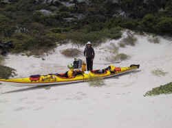
Heading to Santa Rosa Island by kayak, you have two choices (depending on the time of year): If you want to go quickly, you can just paddle the 21 miles from Cuyler to the Pier in Becher's Bay. From the pier, you will have a 1.3 mile flat walk to a campground with hot showers, plumbed bathrooms, and excellent wind shelters. This route is practical for those in a hurry, but Janet and I were more satisfied taking the longer route around the South Side of the island. Since we were kayaking before September 16th, we were only allowed to beach camp in the area between Johnson's Lee and East Point. This made for a 21 mile paddle to Johnson's Lee. If you go a little later in September, you could camp at China Camp (also along the South Side). This would make for a shorter paddle in one day. The day we did this, there was a 5 foot South Swell. As you might imagine, this made landing and take-off quite tricky. Fortunately, we had a double kayak - so the next morning's launch involved me running with the kayak as Janet paddled with all her might. I swam out to meet her once she was beyond the breakers. I suggest you check your weather radio before you decide whether to go South or North. Our camp at Johnson's Lee was wonderful and Quiet - but the swell made things tense during arrival and departure. This was truly a great experience getting to camp here.
The next morning, we headed for Becher's bay. From Johnson's Lee, this is about a 16.5 mile paddle (to the pier). Therefore, by going around the South end, you will do 37.5 miles instead of the 21 miles around the North end. We assumed that landing at the Pier was a good idea. I'd strongly suggest that you skip landing at the pier. Instead, land here: N 33.99447 W 120.04153. This will leave you with a MUCH shorter walk to the campground. There is a good place to hide your kayak on this beach, and if you are coming from the South Side of the island, you won't have to kayak as far (it will also shorten your trip to Santa Cruz a bit as well). We really wished that we had landed here (oops).
Santa Rosa has excellent facilities, and Ranger led hikes. There is a "hunt" going on for most of the island, you are kind of restricted in terms of hiking. From talking to the volunteer, it sounds like you just need to let them know where you will be hiking so you don't accidentally become a target. We did the Lobo Canyon hike and the Torrey Pines hike. We were impressed with both of these trips. We'd highly recommend doing them with the volunteer - it's much more fun. Our volunteer's name was Kathy, and she was friendly, and knew the island very well.
Leaving from Santa Rosa Island, we opted to take the Island Packers ferry. As mentioned before, it is definitely possible to paddle to the Prisoners Cove landing and hike to the Del Norte Campground - but it would likely be too tiring for all but the most accomplished kayak teams.
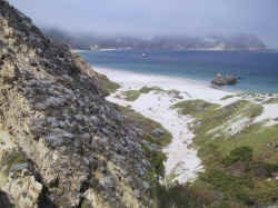
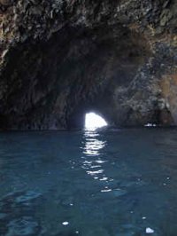 Santa Cruz Island is probably the most visited island of the four. There are good kayaking opportunities here (just for short trips). And most of the cave exploring goes on here. We didn't see any sizeable caves on San Miguel or Santa Rosa. In order to do as much as possible by Kayak, we went to Prisoners instead of Scorpion. It was an awesome 8.7 mile paddle from Prisoners to Scorpion. We were very glad to do this paddle because the views are stunning. As you near Scorpion, there are lots of caves to explore (and a lot more people). We even went through some tunnels with our double 22' kayak. The best kayaking (in my opinion) is along the North side of the island - and the scenery is fantastic. The entire North side is beautiful and rugged - rock. The south side is grassy and a little less rocky. The campground at Scorpion Cove is a short walk, and like the Santa Rosa Campground, it has potable water. One note about the water situation - San Miguel and Anacapa supposedly don't have water. I'd suggest that you assume this is true. Nevertheless, we found some filterable water streaming down Nidever Canyon - even in September. Also, the maintenance guy at Anacapa promptly offered us some water - apparently visitors had left behind large quantities of water. I wouldn't rely on either of these sources, but in the event of an emergency, you may decide to tap them. A water filter might be handy on this trip if you think you will spend more time backcountry camping. We hiked to Smugglers cove, and found that the kayak landing situation was more difficult than at Scorpion. Most of the inner island is dry and hot. We only did two hikes on Santa Cruz island; I felt that the snorkeling and kayaking was very good on this island - but the hiking was so-so.
Traveling from Santa Cruz to Anacapa might be the most popular crossing (of the four possible crossings being San Miguel to Santa Rosa, Santa Rosa to Santa Cruz, Santa Cruz to Anacapa, and Anacapa to mainland). I suspect that this crossing is also the most likely to be calm because Santa Cruz Island creates a significant lee unlike some of the smaller islands. With a strong Northwesterly, you might still get pretty calm conditions 1/2 of the way to Anacapa. The day we opted to travel to Anacapa from Santa Cruz, the water was glassy. It was a great paddle, and once we arrived to the Western tip of Anacapa, we got to explore the shore. You can spend plenty of time exploring this shoreline if the weather is good. The only place you can land easily would be Frenchy's cove. No camping is allowed here. If the waves aren't too big, you can cross to the other side of the island between West and Middle Anacapa, and Middle and East Anacapa. There are some tide pools on the South side of Anacapa - adjacent to Frenchy's cove.
When we made our reservations, we planned to spend 3 nights on Anacapa. This was probably a mistake - we ended up spending just one night on the island. The island has about 2 miles of trails to hike, and you are pretty restricted as to where you can go in other parts of the island. We were able to paddle from Santa Cruz, leisurely explore the Anacapa shoreline, do all the hikes, and even go into the light house (an unexpected treat thanks to the maintenance guy) all in one day. I suppose that you could spend a second day if you went snorkeling, and exploring the South side of the island. We didn't do that because getting our double kayak up using the hoist was a bit of a hassle, and the weather mandated that we leave.
It's worth preparing for the hoist before you depart on this trip. We opted to unload the hatches before pulling out boat out of the water. In retrospect, this was a bad idea. The water in the cove was surging up and down about 3 feet. I straddled the moving kayak - trying not to float away from the ladder while handing gear to Janet from the hatch at the same time. It's quite amazing that neither of us fell in or drifted into the blow hole a few feet away! Janet had to carry gear up the ladder; imagine climbing a ladder with 20 -30 pounds, and the use of just one hand! Putting the kayak back in went much better because we thought about it more. The plan we devised was to load the kayak prior to using the hoist. I'd suggest hoisting your kayak out of the water with gear in the hatches as well. Attaching to the hoist was easier the second time around too. The hoist attaches at a single point. You can pull your boat out like a fish if it's plastic, but a cleaner way of extraction would be to tie a tight line between your bow and stern loops, and hook the line in the middle (kind of like how you hang a picture with a wire going across the back). Since our kayak was so long - and laden with gear, we reinforced this line by tying 1" tubular webbing circles around the midsection of the kayak as well. This distributed the weight bearing portion over more of the kayak. You will still have to straddle your kayak as it's bobbing in the water to do that step - unless you have carabineers and pre measured sections of webbing which you can loop under the kayak while you're in it.
 The paddle from Anacapa to the mainland has a new hazard - you will be crossing one of the busiest shipping channels in California. Those giant ships look small from far away, but they get closer more quickly than you might imagine. The day we decided to leave Anacapa was fairly blustery. By the time we were on the water, wind waves were averaging 4 feet crest to trough, and there were white caps everywhere. Being in the trough of a wave makes it difficult to see who is coming, so I'd suggest picking a calmer start than we did for this crossing (the shipping lane is really close to Anacapa - so you will be out of it just a few miles after leaving). We were somewhat concerned by the combination of challenges - so our adrenaline charged crossing to Oxnard only took 2 hours and 45 minutes. Standard crossing time is 3 to 4 hours... but I've read reports of it taking 6 to 7 hours. One final thing to think about - Island Packers boats to the outer islands only leave from Ventura. This means that if you want to get back to your car from Anacapa, you will have to paddle to Ventura - 16.5 miles as the crow flies by my GPS. The trip to Oxnard is only 12.6 miles (also as the crow files). Also, heading to Oxnard may be more favorable, depending on the direction of the wind and seas. You can see from our GPS track that we found it was initially easier to paddle towards Ventura - but then we eventually arced toward Oxnard (mainly to get off the water sooner).
Landing in Oxnard provided us with the last challenge of our trip - getting the car. Since I hadn't stashed a bike at the Oxnard harbor, I had to run in sandals to do the pick up. I'd advise planning alternative transportation prior to departing - in case you have to land in Oxnard and your car is in Ventura.
Kayak safety is too broad of a topic to discuss in this short write up. Obviously undertaking a trip of this scope can be dangerous. Please be responsible and make sure that you and everyone in your group is very well prepared for all of the possible dangers that can be encountered on this trip. Some of the main dangers to kayakers are hypothermia, collisions with rocks, injury during surf launch / landings, and collisions with other vessels. There are many precautions that one can take to be prepared to deal with and prevent these dangers. Other dangers, which are more difficult to prepare for can include drowning and aquatic predators. No matter how much time you have on the water, one of the most important skills an experienced kayaker can have is knowing when to stay on land.
Outfitting:
Seaward Passat - K2 kayak
Fees:
Camping fees are required for each island campground. You will need to pay for transportation to and from any of the islands.
Resources:
We found out later that National Geographic puts out the best map for this area. We used nautical charts downloaded from NOAA.
See more charts and pictures from this trip here.
Trip Details
- Trip Duration: Extended Trip
- Sport/Activity: Kayaking
- Skill Level: Advanced
- Water Type: Open Water/Ocean