
Cape Fear River (Northeast) in North Carolina
Trip Overview
This trip was a reconnaissance of the Northeast Cape Fear River for an upcoming boy scout trip scheduled for 26-30 Dec. For the Scouts, the trip will be five full days of paddling, but for my recon, I did 3 days of 19, 18, and 13 miles respectively.
The weather for this weekend after Thanksgiving was wonderful, with the exception of the first night with temps in the low 30s. I don't mind cold weather, though.
Our put in was the Wildlife Boating Access at Hwy 41/50 near Chinquapin. We had planned to be on the river by 0630, but I (trip planner) overslept and put us behind schedule. We actually launched at approximately 0830, after staging the other vehicle at the first night campsite. That campsite is on private property and I had previously gotten permission on an earlier road recon of the area.
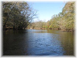
The water was still pretty high from normal; about 3-4 feet, and the current was pretty strong for our coastal flatwater streams. I see this as a bonus when paddling nearly 20 miles as the current helps us to put miles behind us. The wind that first day was also a bit of an issue, but not totally unmanageable. There were a couple of instances where the current pushed us into some strainers, but nothing serious.
We stopped for lunch at Wayne's Landing. Pretty neat place with an artesian spring. Permission for camping and picnics for groups of 10 or more can be obtained from the Northeast Ruritan Club (Edward Bradshaw (910-285-5765) in Wallace).
From there we continued on to the campsite. Our total time for the first day was about 6 1/2 hours. Not bad for 19.4 miles. We had some of the best chili I have had in a while for dinner, and turned in around 2000.
 The next morning, we got up and had pancakes for breakfast and broke camp. We shuttled vehicles for the second day and hit the water around 0930. We figured that would leave us plenty of time as we weren't even pushing dark at the previous night's campsite. On this day, we camped by the Whitestocking Wildlife Boating Access at the end of Whitestocking Rd. For simplicity, we used the tailgate of my truck for our kitchen area and had a pretty peaceful night. Quite a bit warmer than the night before. We turned in around 2130.
What a night! We actually slept until 0700. Time for the last leg of the trip! This leg will take us up Holly Shelter Creek to Shaken Creek. We had breakfast and shuttled vehicles in preparation for launch. I made the mistake of positioning the lead vehicle at the Holly Shelter Creek Wildlife Boating Access on Shaw Hwy. That was actually the halfway point for the day. When we got there, we had to shuffle cars again and position one at the Shelter Creek bridge for takeout.
Paddling up Holly Shelter Creek proved a bit more difficult than the previous two days due to the current. Where the GPS had averaged our speed on Friday and Saturday at 3.5-4 mph, we only made about 1.5-2 mph for the last leg.
All in all, this was an excellent weekend trip, with great weather, good food, good fellowship, and great paddling. I would recommend this route to anyone interested in putting serious miles over a couple of days.
If you have any questions about the route or want more info, contact me (ssgtrob2336-at-gmail.com). I can send the Google Earth File for this trip and answer any questions you may have.
Accommodations:
Primitive campsites with no amenities, except for Wayne's landing which has picnic tables and the Artesian Well for water.
Outfitting:
18 ft Aluminum tub.
15 ft cedar strip work of art.
Fees:
Camping at Wildlife Boating Accesses requires a special use permit. Contact NC Wildlife Resources Commission (http://www.ncwildlife.org/Regs/Regs_BAA.htm).
Resources:
Google Earth and "Paddling Eastern North Carolina with Paul Ferguson" 2nd Edition
Trip Details
- Sport/Activity: Kayaking, Canoeing
- Skill Level: Intermediate
- Water Type: River/Creek (Up to Class II)