
Candies Creek in Tennessee
Trip Overview
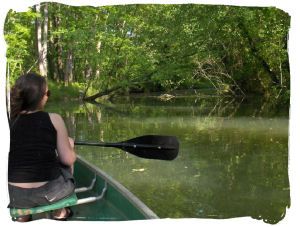
For the past 15 or so years I have often paddled up Candies Creek, entering it's somewhat hidden mouth from the swampy backwaters of The Hiwassee River. Beginning at the end of the creek does mean you are going up stream but it is deep, wide and requires no extra effort really. What test your skills the most is navigating the various trees whose root systems have lost the fight and have come down in the creek. Often you pass under them or over the trunk, it's branches protruding up from the water. Never once has it been the same. Heraclitus did write: a man never crosses the same river twice, the river and the man have both changed. So it goes with Candies Creek. This summer I made it as far as I had ever gone, turning around for want of more daylight and dinner. It is a very scenic exploration, you are in the shade for the most part as you paddle. The woods are virgin, I have seen some massive trees from the creek, no houses or otherwise have been built as far as I have explored, it is unspoiled and less than 10 minutes off of I-75.
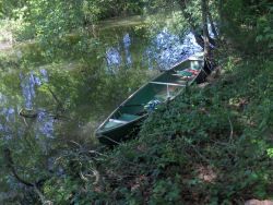
The banks are steep at times and it can be challenging to make land fall. Years ago I suffered a swamping due to this fact, my friend slipped as he was exiting the boat. I went in and floated a ways down before I could recover our goods and the canoe. The current is not very swift and there are no rocks, only dead fall from the trees and the trees themselves at times. No one ventures here from what I have seen, the Put-in I use is a popular bank fishing spot, power boats stay away. A PFD is a sure thing to have, this is deep water and not often traveled, there are no ready made places to climb out.
Heading in from I-75 on Lower River Road you cross the bridge, parking is on both sides once you have come over the bridge. The larger parking spot is to the left, this side of the bridge is the proper side to gain access to the creek mouth. Once you put in you can see some concrete structures in the water along the tree line. These mark the entrance to The Old Mill Channel. I suppose this mill was fed by Candies Creek at one time, the Mill Channel is neatly dug making a long thin island, you can shoot between the concrete structures or stay left, last I tried the Mill Channel was obstructed by dead fall, a problem I will remedy this winter when the water is down and I can hike it. Come around and enter the Mill Channel from it's old feed point, there is a nice root system here to step out on. Explore around and you'll find some very old foundations of what I think was a house, hike back down the Mill Channel and there is more foundations near the concrete structures. I usually run my metal detector and always find something neat. I would guess the foundations date to the early 1900's or before, a massive tree grows up in the middle of the house perimeter. I have researched a bit and have found nothing concerning the history of what was here. I did find this though, a passage from the written history of one Isabel Cobb, born in 1858 on a farm on Candies Creek, in Bradley County. She moved in 1870 to Oklahoma, writing her childhood memories down of living in Tennessee later on.
"On Feb. 21, 1863 she gave birth to her fourth baby - a boy weighing 15 lbs. named for his father - Jos. B. Cobb who was away and did not see him till he was 6 mo. old. I can faintly remember the night Jo was born. A midwife old Aunt Betsey Lane and her husband Anderson came down the Creek in a canoe by torch light. Dr. John Long from Cleveland came later and said Jo weighed more at birth than he did at 6 months, tipping the scales at 15 lbs."
 I have a lot respect for that old Midwife, I have paddled the same waters as her but never at night. It can be dark on Candies Creek even during the day, a night trip in that day and age would have been a risky venture. There could be a good ghost story there, of camping on the creek and in the middle of the night an old canoe glides by with an old man and woman aboard, searching for a house that no longer stands, a flickering torch light that appears and disappears up the creek or whatnot. It is also interesting to think of the creek as a commonly used highway almost 150 years ago. It has been deep and wide for as far as I have paddled up it.
Putting the Mill Channel to your stern you enter into a body of water with two exits at the far side. The left is a dead end but it is a scenic warm up to the creek itself. The Mouth of Candies Creek is on the right and several days ago it was somewhat hidden by low branches as it always is. Once you have been slipped in and seen the beauty of it you'll come back for more, it is a wonderful place and there is a lot of exploring in the area besides the creek itself.
Accommodations:
The Ponderosa Truck Stop is the last place to stop for food.
Fees:
None
Directions:
Off of I-75, take exit 33 for Charleston. The Ponderosa Truck Stop is here and is a fine place to get drinks and whatnot. If you heading North on 75, you will make a left and cross back over I-75, coming South you will make a right. You will be on Lower River Road (SR 308) now, the Ponderosa will be on your left, keep going. After 3 miles or so you will see a sign and road on your right for B & B Marina, this is Hiwassee Access if you want. Keep going you are close. The road straightens out and you will see water to your right through the trees. There is a little dirt parking lot in the right if you want to put in and paddle there. Keep going an you'll begin to to see swampness on your left and right, then a nice new bridge, with small gravel parking lots on both sides. This your put in.
Launches:
There is often folks fishing here, near the parking lot to the left as you cross the bridge there is a little creek that I use to not disturb folks if they are fishing.
Resources:
State Map shows the bridge and Candies Creek by name if you need some help finding it.
Trip Details
- Sport/Activity: Canoeing
- Skill Level: Intermediate
- Water Type: River/Creek (Up to Class II)