
Cacapon River in Virginia
Trip Overview
The Cacapon River meanders through West Virginia, just west of the panhandle area. This river is rated by others as having some sections at Class II, but except for three ledges along this trip all about 2' in height, nothing was very challenging, which is not to say it was not fun, it was. Three of us made the trip in 10' rec kayaks and we had no problems, although we used skirts, which saved us from taking a lot of water in the boats.
There are not many places to put-in/take-out along the Cacapon, we chose to make about a 4 hour trip of it by putting in at the RT 50 bridge in Capon Bridge, WV and paddling north to the 127 Bridge near Forks of Cacapon, WV. The put-in point is beside a small shop and there is an honor system payment of $5/boat to use their access and park. There does not appear to be much of anywhere else to park, although there is apparently a WV DNR site you can put in several miles downstream, but we did not want to cut that much off the trip.
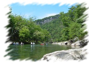
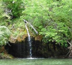 The trip is punctuated with many gravel bars and small whitewater, although some long stretches require paddling to keep the pace up. There are some very scenic areas, with tall cliffs with tree studded rock faces coming right to the river. When the weather is wet, like on our trip, there are some pretty waterfalls, including a set you can paddle under to cool off.
This was a great trip, and the river was shared by some other paddlers, but not too many. The only downsides are the prevalence of pretty shabby riverside shacks, and reports that most of the summer you have to drag your boat through a lot of areas.
I highly recommend this trip if you are close enough to make it. I do caution you not to depend on GPS in this area, we spent a good amount of time having ours send us down dead-end roads and making wrong turns. Know where you are going.
Accommodations:
No bathrooms on either end, although there are some gas stations along the shuttle route. Not much of anywhere to eat we could find, we went back to Winchester when we were done.
Directions:
To take-out, take Rt 127 W from RT 522, N. of Winchester, VA. Parking is under the near side of the 127 bridge over the Cacapon. To get to the put in, go back east on 127 to a right on I.L. Pugh Road, then turn left on Smokey Hollow Rd. Follow Smokey Hollow to the end and turn right on Rt 50. Follow Rt 50 to the town of Capon Bridge, the put-in is on the far side of the river on the right, turn immediately after crossing the bridge. The local cops seem to consider the approach to the bridge a good place to set-up radar, obey the speed limit. Smokey Hollow and IL Pugh are hardtop, if you get on a gravel road (like us), you are heading to a dead end.
Resources:
There does not appear to be much out there on paddling the Cacapon. Google 'Cacapon river paddling' and you will find some information. Use your smarts to refine the search. I used Google Earth to scout the area a bit, but the imagery for most of this section of the river is Landsat (in other words, not very helpful). The WV DNR site at the link below might be useful for some folks:
http://www.wvdnr.gov/Fishing/public_access.asp
Trip Details
- Sport/Activity: Kayaking
- Skill Level: Beginner
- Water Type: River/Creek (Up to Class II)