
Buffalo River in Tennessee
Trip Overview
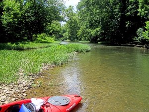
We paddled from Texas Bottoms to the take out at Buffalo Canoeing 7 miles down stream.
The river moves fairly fast and most of this stretch is mild rapids punctuated by flat still water stretches. The Buffalo River is chock full of deadfall and strainers. Since this river moves fairly fast and has lots of turns with strainers at the end, this is not a great river for novices. There are places at this time of year that are too low to paddle and you will have to portage over them, but this is really just at the outset.
100 yards in from the Texas Bottoms put in is a 3 foot set of falls that are way too low to go over this time of year. After that, it's pretty much easy to avoid high centering on gravel in low water.
I would suspect that this river is too low to do much on after June or early July without good rainfall.
Accommodations:
There is camping at the Buffalo Canoeing take out for those inclined and there are hotels in Hohenwald, TN. This is remote and there are no services around for 15 miles and cell service is not existent here.
Fees:
Portage of $5 a person if you use it. They are nice enough to just let you park for free if you are driving two cars.
Directions:
For those who want to know how to get to this place, at Exit 46 on I-65, head west toward Columbia. Stay on this highway (Hwy 99 a/k/a Bear Creek Road) until you get to Hampshire Pike and exit left, then stay on that all the way to Hohenwald (28 miles or so), take a left at Park Street (you have to look for the Hwy 99 sign as the street is not marked) take a quick jog left at E. 4th Ave (also unmarked, but follow the signs for Hwy 20) then take a quick right at Buffalo Road, otherwise known as Hwy 99 and stay on this road until you see a sign marked "Buffalo Canoeing" you will know it when you see it. Ignore any other prompting from your GPS or Mapquest. You have been warned. I have put a pin on Google Map for take out and put in here:
https://maps.google.com/maps/
Resources:
Local paddling books are unhelpful. I posted updated pics and links here:
http://bloggertobenamedlater.com/2012/06/17/kayaking-the-buffalo-river-in-tennessee-an-exercise-in-humility/
Trip Details
- Sport/Activity: Canoeing
- Skill Level: Intermediate
- Water Type: River/Creek (Up to Class II)