
Big Slough Wilderness in Texas
Trip Overview

River Flow: Guage on the Neches River at near Neches, TX read 3.10, approximately 60 cfs.
I paddled twice in the Big Slough wilderness about 20 years ago, and have always wanted to go back. There is plenty of water to paddle without making the trip that far for me, however, and so Big Slough sat in the back of my mind as a special place Id get back to sometime. It is alluringly remote and wild in my imagination. There is no telling what is out there. You might see a bobcat or river otter -- or even a mountain lion or a bear. You will certainly see gorgeous bottomland hardwood forests and river line plant communities.
The fire that impelled me on this trip was kindled by a gift from a paddling friend. "Paddling the Wild Neches" by Richard Donovan, Texas A&M University Press, is a wonderful new book about Donovans trip down the Neches and through the heart of East Texas history, folklore and natural beauty. Donovan mentions exploring the entrance to Big Slough while on his journey. As I read his account of the area it occurred to me that Id be heading to East Texas in a couple of days and would be within a 2 hour drive of Big Slough. Before I could get too rational about it, I factored an extra day into the trip.
Much of the East Texas countryside was blanketed in fog on the drive up. Id forgotten the county road map and a few false turns slowed me a bit, but soon I was at the put in. The Forest Service is doing road improvement work in the area. Hopefully improved signage is in the budget. The end of the drive is an unpaved pull out off a gravel road. The only sign is a warped and weathered 2x 3 plywood board that says "Big Slough Wilderness" with an arrow pointing toward a foot path leading into the woods.
Sources Id found on the net suggested that the canoe trail might be seldom used now due to log obstructions. I half expected the trail down to the launch, which had been an open two-track logging type road, to be completely grown over and impassable. Nevertheless, a quick mile walk down the footpath took me to the slough, and the trail was open enough to carry the canoe down. The slough was very low, but it looked like it would float the canoe and the logs and branches in it could be negotiated with a little patience. A single carry soon had the canoe and day pack at the waters edge. (Note that a potential put-in spot on Hickory Creek, where it is crossed by the 4-C hiking trail, that avoids the need to make this carry in, is apparently used by some) I headed upstream intending to cover the mile or so to the sloughs opening on the Neches.
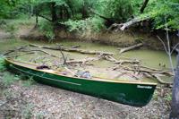 After 2 or 3 pull-overs and an equal number of drag-arounds, I reached the short side channel that the map suggested was about half way to the river. Oh for another foot of water! That would have made all or nearly all the obstructions I encountered passable without stepping out of the canoe. The sky was darkening and the tree tops were getting restless. Storms had been predicted and another pull-over lay just ahead. I turned around and headed back the way Id come. More exploration could wait for when I had a few companions with me for safety, I thought.
When I got back to the put in, the sky had lightened and I was tempted to explore down stream a little ways. Again, I made about mile distance with only one brief step out from the canoe. At the last pull over a thunderhead became visible through an opening in the canopy. It only brought a brief shower, but I had stopped again and lost momentum. Good sense said to carry out of the steamy woods while I had plenty energy left.
Im still trying to gather more information on Big Slough and hope to make contact with others who paddle it. One question I have is how well the nearest Neches River gauge correlates to water level in the slough. It ought to correspond very closely. Id also like to explore the possibility of putting in at Hickory Creek, which supposedly adds three miles to the trip, but saves the half-mile carry in at the Scurlocks Camp launch site. It looks like the Forest Service is improving the road in to Big Slough and that would help, particularly in wet weather.
Some things to consider if you go:
- This is a potentially hazardous trip in a remote area.
- My cell phone didnt work at all.
- Be in good physical condition.
- Use good judgment on how far and fast you push yourself.
- Go with a friend or friends for fun and safety.
- Take a good map, compass and your GPS if you have one.
- Take bug spray and plenty of water.
- Check on water levels and potential paddling conditions before you go.
- Pack so that if you do encounter pull-overs and drag-arounds you arent wrangling with piles of loose gear. Waterproof packs or lined packs make the most sense to me.
- Go with a sense of adventure and flexibility.
- If you want a sure thing, with no chance of obstacles or changing plans, this may not be a good destination for you.
- Plan to get muddy; bring a change of clothes and shoes.
One reference I saw on the web describes Big Slough as "The premier paddle in East Texas." Another dismisses it all together, advising that Big Slough "seldom has the right amount of water for this to be a useful trail." The enigmatic wilderness itself cant answer the questions raised by those disparate views, but is out there waiting for further exploration. My opinion, currently somewhere in the middle of those two, is still forming
Resources:
For More Information:
Davy Crockett National Forest
Rt. 1, Box 55-FS
Kennard, TX 75847
(936)-655-2299 Monday - Friday
Here is a link to a topographic map of the area. In the window to the left of the screen are tools to resize the map as you like.
Trip Details
- Sport/Activity: Canoeing
- Skill Level: Advanced
- Water Type: River/Creek (Up to Class II)