
Angelina Neches Forks in Texas
Trip Overview
 The name "Angelina-Neches Forks" refers to the confluence of the Angelina and Neches Rivers in deep East Texas. The confluence is in the backwaters of B.A, Steinhagen Reservoir, which is created by Dam B. That dam is but a short distance below Sam Rayburn Reservoir on the Angelina River, the largest reservoir exclusively in the State of Texas.
Although the Big Thicket National Preserve starts immediately below Dam B, the Forks is well within the historical Big Thicket, a vast area of forest and swamp in East Texas. Inaccessible, the Big Thicket is said to have been a hideout for outlaws and escaped slaves.
Although reservoirs are often criticized for drowning out rivers, Dam B has enlarged a beautiful swamp in and around the "Y" created by the rivers' confluence. That swamp offers wonderful paddling opportunities. You can reach the Forks either from Bevilport, which is upstream on the Angelina River, or from Martin Dies, Jr., State Park, which is on the northeastern shore of B.A. Steinhagen Reservoir.
On the afternoon of August 15, 2002, I arrived at Martin Dies, Jr. State Park intending to paddle up to the forks, camp, and explore the swamp the following morning. The weather, however, was drizzle punctuated by downpours. Instead of paddling and camping in the rain, I rented a screened shelter at the Walnut Ridge Section of the park, leaving the paddling for the next day. The screened shelters are tidy and include a concrete floor, a picnic table, and electricity. Grills and faucets with potable water sit outside the shelters. Clean restroom and shower facilities are convenient to the shelters. Because it was a workday and the weather was lousy, I had the entire campground to myself.
Not far behind my shelter was a grassy area looking out over the water from a revetment. It offered a beautiful view of a marsh and a multitude of water birds. As dusk approached, alligators swam back and forth along the channel that was immediately below the revetment and parallel to the shore. An armadillo snuffled among the camp sites, no doubt looking for dropped food. In the night something larger than the armadillo snorted around my shelter. Early the next morning I saw deer near the restroom.
Under normal circumstances, B.A. Steinhagen is a shallow lake. According to my map, its normal conservation pool level is 83 feet. Because of repair work to the dam, the level was around 78 or 79 feet when I was there. Consequently much of the upstream swamp was drained, and mud flats in the lake proper were evident from the U.S. 190 bridge crossing the lake.
 On August 16, I launched from the park boat ramp approximately 8:15 A.M. alone in my 17-foot Grumman. The boat ramp lets out into a channel parallel to the shore-the same channel that had the alligators. The other side of the channel is bounded by a marsh. To get to the forks, you must go left from the boat ramp for a short distance to the first bend, which is easily visible from the ramp. Turn right at the bend and follow the winding channel for a considerable distance until you eventually come out into the Neches River proper. The Neches is easily recognizable, because it is dramatically wider than the channel from the boat ramp. A red band on the leaning trunk of a dead tree marks where the channel meets the river. I was grateful for that when returning.
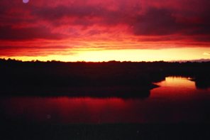
In the morning light, the Forks appeared majestic. My photograph does not do justice to what I saw. I arrived around 10:00 A.M., although most paddlers would have covered the distance faster. The Corps of Engineers estimates the distance from the park boat ramp to the Forks at three miles. Though I was paddling up the Neches and the lake was low, I noticed no current. Of course, Sam Rayburn Reservoir was not releasing water down the Angelina at the time.
Bee Tree Slough is the most popular entrance to the swamp above the Forks. To get to the slough, paddle up the Angelina for a short distance until a cove opens to river left. The cove is full of dead tree trunks and stumps. The slough leads out from the back of the cove.
The slough rapidly narrows, particularly at the lake level at which I paddled. It is filled with cypress trees and fallen logs. Quickly you move from paddling a wide river suitable for power boats to slipping through a narrow and heavily vegetated backwater. Unfortunately, after about 20 minutes I reached a stopping point.
Although I had managed to get past numerous fallen logs and other obstructions, I finally would have had to wrestle my canoe over a major log jam with entangling branches. Although I have plenty of experience doing so, wrestling canoes over log jams is never fun and doing so this time would have required me to wade in murky, knee-deep water with a mucky bottom. I passed on the log jam given the potential for snakes, of which I had seen none, and for alligators, of which I had seen many.
I pulled over to shore, had a bite to eat, smoked a cigar, snapped a few photos, and retraced my steps back out of the slough. Even at normal water levels, there would be unsubmerged land in the swamp suitable for stopping and resting. Much of the land is covered in trees and other non-aquatic vegetation.
At higher water levels, the area is networked by interconnecting channels. I was concerned about getting lost, but there was no danger of that with the water as low as it was. Bee Tree Slough was the only channel with significant water, so I was able to paddle out without wondering on which channel I had paddled in.
 Once back on the Angelina River, I pulled over to a Corps of Engineers campsite. To camp in the area, you must get a free Corps of Engineers permit and camp in the specified site. The only improvements to the site I visited were a well-maintained sign announcing the need for a Corps permit and two fish cleaning tables that were about to collapse. There was litter from previous users, including two lawn chairs. One of those held my weight long enough for me to snooze in the shade of the forest.
Despite an upstream wind that had picked up as the day progressed, the paddle back went quickly. I encountered a fisherman at the park boat ramp who was surprised I had paddled as far as Bee Tree Slough. When I mentioned not seeing any snakes in the entire trip, he observed "the gators ate 'em out." Whether or not that is so, their absence was a significant contrast to a trip I took 28 years ago lower on the Neches in Hardin County. Eight of us paddled for three days, over a day of which was in sloughs off the main river channel. Although no one was bitten, without exaggeration, I saw more snakes on that trip than I have seen in all the rest of my 50+ years put together. Thus I expected snakes on this trip.
Whether or not they ate out the snakes, alligators are plentiful. It was common to see a slight protrusion above the water surface that slipped underneath when approached. On several occasions my paddle bumped something where the surface offered no clue of logs or other obstructions. That sometimes occurred just after one of the protrusions had sunk below the surface. Surely hidden logs were responsible for some of those occasions. I'm not sure they were responsible for all of them. On at least one occasion I had the definite sensation that what I bumped with the paddle was moving.
I was back at the boat ramp about 2:30 P.M. It was a delightful trip for anyone with the will and the ability for a seven or eight miles round trip in flat water. You will be rewarded with a visit to what has been called one of the last truly wild places in the state. You can get to the Forks only by boat, and you can get into the back reaches of the swamp only by paddle craft.
I have heard that the Corps of Engineers is planning to raise the level of Dam B to increase storage capacity. Doing so will drown out the swamp. Not only is this a trip worth taking, but it is one that must be taken soon if at all. If I am able to go back when the water level is normal, I would paddle up to a campsite near the Forks the first afternoon and have all the next day to explore the swamp more thoroughly before paddling out. If there is enough water to really get back into the swamp, a good map, a compass, and a GPS are essential. If properly equipped, you will find this what, in Texas, we call a bodacious trip.
Accommodations:
Martin Dies, Jr. State Park offers tent camping and screened shelters. If you have a Corps of Engineers permit, you can camp on designated sites along the Angelina River. Motels are available at nearby Jasper and Woodville.
Fees:
The Corps of Engineers camping permits are free. Martin Dies, Jr. State Park has the same fees as any other Texas state park.
Directions:
Take U.S. 190 west from Jasper to Martin Dies, Jr. State Park
Resources:
Pace Hill and Town Buff USGS quandrangles. I used a Topozone map at 1:15,000.
Trip Details
- Trip Duration: 2-3 Day Trip
- Sport/Activity: Canoeing
- Skill Level: Beginner
- Water Type: Flat/Sheltered Water