
Alligator River National Wildlife Refuge in North Carolina
Trip Overview

The Alligator River is 158,000 acres of wildlife preserve. The river portion I paddled was more lake than river due to the size until reaching the innermost portion. The water was black with tannin and had little to no waves.
There are virtually no houses anywhere to be seen from the water and on the Monday I was there, I saw nobody on the water the entire day. I put in at the end of a road called Buffalo City Road where there is a nature trail, porta potty and a small wooden bridge. Surprisingly, for as desolate a place as this is - the one other car I saw in the parking area must have been owned by delinquents as when I returned to leave one small window of my car was smashed in. Oh well - unfortunate and not likely regular issue.
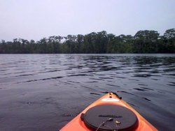 Surprisingly, for all the shoreline beauty of the cypress, pine and undergrowth, there was very little wildlife to be found. I fished some but never got a bite, I kept a keen eye out for turtles, snakes, alligators, anything! Even the birds were scarce beyond what I heard in the distance. Just me and the dragon flies - but other bugs weren't bad.
I paddled about 4 miles up the narrowing river but recognized my limit after a busy paddling weekend so then returned. There are brochures available to show the "trails" to paddle and there are a few colored post markings but you would need to really be on top of them to see the colors. I used the brochure map and shoreline to keep track of my route. It was definitely a place to be alone with yourself for a nice afternoon paddle.
Accommodations:
Manteo has lodging and conveniences - about 15 minutes away.
Fees:
None
Directions:
From the Outer Banks, drive toward Manteo but continue straight over the new bridge to Manns Harbor. You will parallel a waterway for a while then see signs for the park admin office which is a ways down a gravel road. If you don't go to the office, stay on the paved road another 10 minutes until you see Buffalo City Road on the left. Go to the very end and launch.
Resources:
Google "Buffalo City Road, North Carolina" in Google maps for great locating directions.
The free brochure available at the park office.
Trip Details
- Sport/Activity: Kayaking, Canoeing
- Skill Level: Beginner
- Water Type: Flat/Sheltered Water